Wind shear: an invisible enemy to pilots?
Source: Airbus Safety First URL: https://safetyfirst.airbus.com/wind-shear-an-invisible-enemy-to-pilots/ Published: 2015-01-29 Magazine Issue: 2015-01 Category: Flight Ops, approach, burst, cumulonimbus, doppler, downburst, downdraft, draft, gust, landing, LLWAS, microburst, pirep, PWS, radar, RWS, shear, storm, takeoff, TDWR, thunderstorm, weather, weather radar, wind, windshear PDF: Original PDF
Wind shear
Weather plays a significant role in aviation safety and is regularly cited as a contributing factor in accidents or major incidents. Wind shear in the form of microbursts particularly, can be a severe hazard to aircraft during take-off, approach and landing.


JEAN DANEY Director Flight Safety – Accident Investigator
XAVIER LESCEU Experimental Test Pilot

As commercial aviation began to develop in the middle of the last century, we knew very little about wind shear. The detection and reporting of wind shear related events was actually really poor. Yet, in its many forms, although actual encounters with severe wind shear are fairly remote in a pilot’s career, this phenomenon can change a routine approach into an emergency recovery in a matter of seconds.
As research and technology progressed, we have learned to identify, prevent and if necessary, handle such events.
We will look at the effects of wind shear on an aircraft and at piloting techniques for coping with a shear situation, focusing more particularly on microbursts.
UNDERSTANDING WIND SHEAR
Section titled “UNDERSTANDING WIND SHEAR”Definitions
Section titled “Definitions”>> Wind shear
Section titled “>> Wind shear”Wind shear can be defined as a sudden change in wind velocity and/or direction over a short distance. It can occur in all directions, but for convenience, it is considered along vertical and horizontal axis, thus introducing the concepts of vertical and horizontal wind shear:
-
Vertical wind shear consists of wind variations along the vertical axis of typically 20 to 30 knots per 1000 ft. The change in velocity or direction can drastically alter the aircraft lift, indicated airspeed, and thrust requirements when climbing or descending through the wind shear layers.
-
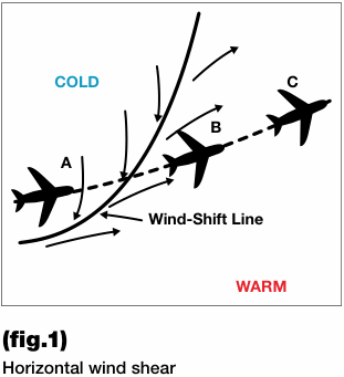
Horizontal wind shear consists of variations in the wind component along the horizontal axis – e.g.
>> What is a microburst?
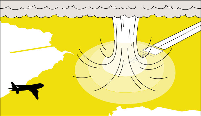
Section titled “>> What is a microburst?”A microburst clearly creates the most dangerous forms of wind shear. It consists of a small column of exceptionally intense and localized sinking air, which descends to the ground (called “the downdraft”) and upon contact with the earth’s surface, diverges outwards in all directions, thus forming a ring vortex. It is capable of producing powerful winds near ground level.
decreasing headwind or increasing tailwind, or a shift from a headwind to a tailwind – of up to 100 knots per nautical mile. (Fig.1) shows how a penetration would appear as an aircraft crosses a cold front.
This weather phenomenon can occur at many different levels of the atmosphere; however it is most dangerous at the lower levels, as a sudden loss of airspeed and altitude can occur.
It is usually associated with the following weather conditions: jet streams, mountain waves or temperature inversion layers, frontal surfaces, thunderstorms and convective clouds or microbursts, occurring close to the ground.
Microbursts are either dry (i.e. little or no rain reaches the ground) or wet (usually within a downpour). They typically form under or close to thunderstorms and cumulonimbus clouds in particular (fig.2).
The radial pattern means winds of various directions within a small area, and hence considerable wind shear near the ground, for up to several minutes.
The change in velocity or direction can drastically alter the aircraft lift, indicated airspeed, and thrust requirements when climbing or descending through the wind shear layer.
Wind shear
(fig.2)
Microburst caused by a cumulonimbus
Typical characteristics of microbursts
Section titled “Typical characteristics of microbursts”Size
Intensity
Duration
Visual signs
Covers an area less than 2.5 nautical miles in diameter.
Downdrafts are 40 knots (4000 ft/minute), horizontal winds between 45 and 100 knots.
Approximately 15 minutes.
Often associated with heavy thunderstorms, embedded in heavy rain.
Microbursts: a threat to aviation safety
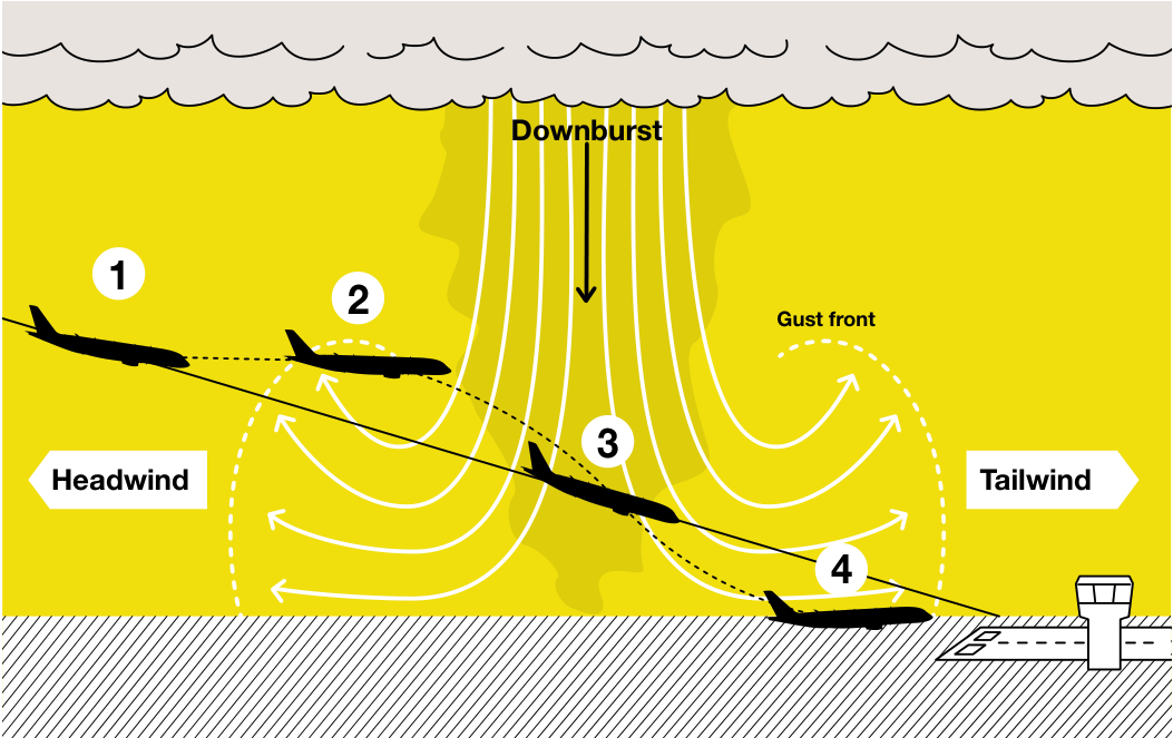
Section titled “Microbursts: a threat to aviation safety”From a safety perspective, microbursts bring a threat to aircraft due to the scale and suddenness of this phenomenon. To put it briefly, microbursts combine two distinct threats to aviation safety (fig.3) :
- The downburst part, resulting in • The outburst part, resulting in large strong downdrafts that rapidly push horizontal wind shear and wind the aircraft downward. The power of component shift from headwind to the downburst can actually exceed tailwind. This sudden change from aircraft climb capabilities. headwind to tailwind reduces the lift of the aircraft, which may force the aircraft down, typically during takeoff or landing.
An aircraft actually encountering a microburst in the vicinity of an airfield while it is about to land or take-off, may be flying through 3 different and difficult phases of wind conditions at a critical phase of flight, at low altitude. For example, an aircraft flying through a microburst at landing should expect to encounter the following phases:
>> Phase 1: Headwind
Section titled “>> Phase 1: Headwind”-
When first entering a microburst, the pilot notices a performance enhancing headwind gust, which instantaneously increases the aircraft airspeed, thus causing lift and the aircraft to rise above its intended path and/or accelerate (see (fig.3) , items 1 and 2).
-
To descend the aircraft back on its descent path and decrease speed, the pilot will naturally retard the engines and push the side stick, thereby forcing the aircraft to descend.
>> Phase 2: Downdraft
Section titled “>> Phase 2: Downdraft”- As the aircraft continues into the microburst, it meets a sudden surge of downdraft affecting both the aircraft flight path and then the Angle-Of-Attack (AOA): the aircraft will sink and the AOA will increase (see (fig.3) , item 3).
>> Phase 3: Tailwind
Section titled “>> Phase 3: Tailwind”-
As the pilot attempts to climb to recover his/her altitude, the aircraft now experiences a change in wind direction and encounters a tailwind.
-
The pilot, now traveling at a lower speed and pushed downwards, will attempt to regain the original trajectory by initiating a climb.
-
The tailwind gust instantaneously decreases the aircraft lift and airspeed and thus, it tends to make the aircraft fly below its intended path and/or decelerate(see (fig.3) , item 4).
A microburst is a serious threat to flight because of its direct and aggressive impact on the aircraft airspeed, altitude, Angle-Of-Attack, and thus, lift capability.
A microburst is a serious threat to flight because of its direct and aggressive impact on the aircraft airspeed, altitude, Angle-Of-Attack, and thus, lift capability.
(fig.3)
Section titled “(fig.3)”Effects of a microburst on aircraft performance
Wind shear
PREVENTION: HOW TO DETECT AND AVOID WIND SHEAR
Section titled “PREVENTION: HOW TO DETECT AND AVOID WIND SHEAR”Wind shear has a negative effect on aircraft performance and is therefore a real threat to the safe conduct of flight. The best line of defence against such hazards is: detection and avoidance.
Since the discovery of the effects of wind shear on aircraft performance in the early 1980’s, different tools have been developed to help pilots recognize these events, and take appro-
priate actions. In practice, flight crew awareness and alertness are key factors in the successful application of wind shear avoidance techniques.
Wind shear awareness and detection means
Section titled “Wind shear awareness and detection means”The best ways a pilot can prevent an encounter with wind shear is to know wind shear is there and to avoid it where possible. However, should an encounter be unavoidable, it is important to know the likely magnitude of the change, and be prepared to react immediately. Although there is no absolutely reliable way to predict the occurrence, different tools and information can be used to detect areas of potential or observed wind shear, and thus be able to develop efficient avoidance strategies.
A good communication between flight crews and ATC is essential.
>> Weather reports and forecast
Section titled “>> Weather reports and forecast”Many airports – particularly those that are prone to microburst and wind shear – are now equipped with a Low Level Wind shear Alerting System (LLWAS) and/or a Terminal Doppler Weather Radar (TDWR).
These devices are able to detect microbursts and warn aircraft of their occurrences by sending an alert to ATC. In this respect, a good communication between flight crews and ATC is essential.
INFORMATION
Section titled “INFORMATION”The LLWAS is comprised of a central anemometer (sensing wind velocity and direction) and peripheral anemometers located approximately two nautical miles from the center. Central wind sensor data are averaged over a rolling two-minute period and compared every 10 seconds with the data from the peripheral wind sensors.
There are two LLWAS alerting modes: wind shear alert and microburst alert. A wind shear alert is generated whenever the wind speed loses 15 to 29 knots, or gains more than 15 knots. Microburst alert condition is when the wind speed loses more than 30 knots. LLWAS may not detect downbursts with a diameter of 2 nm or less. This system enables Air Traffic Controllers to warn pilots of existing or impending wind shear conditions.
The TDWR enables to detect approaching wind shear areas and thus, to provide pilots with more advance warning of wind shear hazard.
Safety First #19 | January 2015 43
>> Crew observations
Section titled “>> Crew observations”Blowing dust, rings of dust, dust devils (i.e. whirlwinds containing dust and sand), intense rainfall or any other evidence of strong local air outflow near the surface often are good indications
of potential or existing downburst. A large difference between actual wind (on ND) and wind reported by tower can also be a good indication. Therefore it is better to avoid these areas.
>> Pilots’ reports (PIREPS)
Section titled “>> Pilots’ reports (PIREPS)”PIREPS of wind shear in excess of 20 knots or downdraft / updraft of 500 ft per minute below 1000 ft above ground level are all good indications of severe conditions and should be avoided at any time.
Considering that these conditions develop, change or dissipate rapidly, those reports should however be interpreted with great care and judgement. A pilot must consider the amount of time since the report was made. Indeed, knowing that micro-
bursts intensify for several minutes after they first impact the ground, the severity may be higher than that initially reported. Conversely, the microburst reported may well have dissipated by the time the aircraft plans to cross the incriminated area.
Therefore it is very important to remember that the aircraft ahead may experience vastly different conditions than the following one will encounter in the same airspace.
Remember that the aircraft ahead may experience vastly different conditions than the following one will encounter in the same airspace.
>> On-board weather radar
Section titled “>> On-board weather radar”Generally microbursts are accompanied by heavy rainfalls, which can be detected and identified using the
on-board weather radar. Those areas should be avoided.
Wind shear
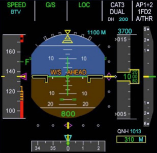
(fig.4) “W/S AHEAD” predictive caution display on PFD
>> On-board predictive wind shear system
Section titled “>> On-board predictive wind shear system”The PWS provides typically a one-minute advance warning by showing first an amber “W/S AHEAD” message on the PFD (fig.4).
Today, most aircraft models have predictive wind shear equipment to warn pilots of possible threats via aural and visual means.
To provide an early warning of potential wind shear activity, some on-board weather radars feature the capability to detect wind shear areas ahead of the aircraft, based on a measure of wind velocities ahead of the aircraft both vertically and horizontally.
If conditions worsen and the wind shear location gets closer to the aircraft, the “W/S AHEAD” amber caution turns into a red warning and is associated with an aural synthetic voice “WIND SHEAR AHEAD, WIND SHEAR AHEAD” during take-off, or “GO AROUND, WIND SHEAR AHEAD” at landing. This is a possible indication that the aircraft is approaching a microburst.
This equipment is referred to as a Predictive Wind shear System (PWS). This system is active and provides reliable indications between 50 and approximately 1000 feet above the ground surface.
>> Summary
Section titled “>> Summary”Flight crew should consider all available wind shear awareness means and assess the conditions for a safe takeoff or safe descent, approach and landing based on:
-
Most recent weather reports and forecast. Pay a careful attention to ATC indications in particular.
-
Visual observations.
-
Crew experience with the airport environment and the prevailing weather conditions.
-
Weather radar implemented at airports. These systems serve to detect microbursts in close proximity to the airport and send out alerts to both pilots and ATC alike.
-
On-board weather radar to ensure that the flight path is clear of hazard areas.
-
On-board Predictive Wind shear System (PWS).
Operational best practices: how to avoid wind shear and get prepared altogether
Section titled “Operational best practices: how to avoid wind shear and get prepared altogether”The wealth of tools and indications listed previously should allow crews to gather sufficient knowledge about the weather conditions ahead, and thus plan accordingly. But how can these pieces of information be best used to be prepared to react and effectively avoid an actual encounter with wind shear? Here are a few tips.
>> Take-off
Section titled “>> Take-off”-
Consider delaying the take-off until conditions improve. Remember a downburst is not a long-lasting phenomenon and can clear within minutes.
-
Select the most favourable runway and initial climb out path, considering the location of the likely wind shear / downburst. This may involve asking ATC for “an immediate left or right turn after take-off to avoid”.
-
Use the weather radar (and the predictive wind shear system, as available) before commencing the take-off roll to ensure that the flight path is clear of hazard areas.
-
Select the maximum take-off thrust.
-
Closely monitor the airspeed and speed trend during the take-off roll to detect any evidence of wind shear.
BEST PRACTICE
Section titled “BEST PRACTICE”If wind shear is suspected, or is detected by the Predictive Wind shear System (PWS), delay the take-off.
>> Descent and approach
Section titled “>> Descent and approach”-
When downburst / wind shear conditions are anticipated based on pilots’ reports from preceding aircraft, or based on an alert issued by the airport LLWAS, the approach and landing should be delayed until conditions improve, or the aircraft should divert to a more suitable airport.
-
Select the most favourable holding point, approach path and runway, considering the location of the likely wind shear / downburst condition, and the available runway approach aids.
-
Select less than full flaps for landing (to maximize the climb gradient capability) and adjust the final approach speed (i.e. VAPP) accordingly.
-
If an ILS is available, engage the autopilot for a more accurate approach tracking.
-
If a gusty wind is expected, consider an increase in VAPP displayed on the FMS CDU (a maximum of minimum approach speed (i.e. VLS) + 15 knots is allowed).
-
Closely monitor the airspeed, speed trend and ground speed during the approach to detect any evidence of imminent wind shear. If the presence of wind shear is confirmed, be prepared for a possible missed approach and escape maneuver. A minimum ground speed should be maintained to ensure a minimum level of energy to the aircraft, and to ensure proper thrust management during the approach in case of sudden headwind to tailwind change. This is automatically performed on Airbus fly-by-wire aircraft by the Ground Speed mini function, when the speed target is managed.
-
• In anticipation of a possible wind shear event, be alert to respond immediately to any predictive wind shear advisory, “W/S AHEAD” caution or warning. And be prepared to perform a missed approach or go-around if necessary.
BEST PRACTICE
Section titled “BEST PRACTICE”If wind shear is suspected, or is detected by the Predictive Wind shear System (PWS), delay the approach until conditions improve, or divert to a more suitable airport.
Wind shear
RECOVERY: HOW TO RECOGNIZE AND HANDLE ACTUAL WIND SHEAR CONDITIONS
Section titled “RECOVERY: HOW TO RECOGNIZE AND HANDLE ACTUAL WIND SHEAR CONDITIONS”Despite the available prevention means, an actual encounter with wind shear can happen. A timely recognition of this weather phenomenon is crucial to allow enough time for the crew to decide on the next course of action.
As far as wind shear is concerned, the encounter, piloting techniques exist for best course of action is almost always coping with a shear situation. avoidance. But in case of an actual
Recognition
Section titled “Recognition”As rare as an actual encounter with severe wind shear may be, timely recognition of this condition is key for the successful implementation of wind shear recovery / escape procedures.
>> How to strengthen the wind shear situational awareness
Section titled “>> How to strengthen the wind shear situational awareness”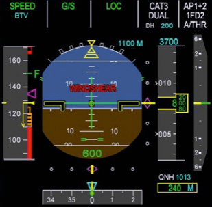
(fig.5) “WINDSHEAR” reactive warning display on PFD
The following deviations should be • Vertical speed excursions of 500 ft/ considered as indications of a possiminute ble wind shear condition: • Pitch attitude excursions of 5
-
ble wind shear condition: • Pitch attitude excursions of 5 • Indicated airspeed variations in degrees excess of 15 knots • Glide slope deviation of 1 dot
-
Glide slope deviation of 1 dot
-
Ground speed variations
-
Heading variations of 10 degrees
-
Analog wind indication variations: direction and velocity
-
Unusual autothrust or auto throttle activity.
>> On-board reactive wind shear system
Section titled “>> On-board reactive wind shear system”A reactive wind shear warning system is available on most aircraft models.
The wind shear warning system associated to the Speed reference System (SRS) mode of the flight guidance constitute the Reactive Wind shear System (RWS), since both components react instantaneously to the current variations of aircraft parameters.
This system is capable to detect a wind shear encounter based on a measure of wind velocities, both vertically and horizontally. When it activates, the audio “WIND SHEAR” is repeated 3 times, and a red “WINDSHEAR” warning appears on the PFD (fig.5).
Recovery technique for wind shear encounter
Section titled “Recovery technique for wind shear encounter”The aircraft can only survive severe wind shear encounters if it has enough energy to carry it through the loss-of-performance period. It can sustain this energy level in the following three ways:
-
Carry extra speed. The aircraft does this automatically when in approach in managed speed (Ground speed mini).
-
Add maximum thrust. The aircraft does this automatically with alpha
floor protection, even if TOGA was already selected (do not forget to disconnect the Autothrust in this case, when out of alpha floor).
- If possible, trade height energy for speed. Any aircraft can do this.
Proper pilot technique helps in this process, providing the following few recommendations are duly followed, in a timely manner.
>> During take-off
Section titled “>> During take-off”If a wind shear is detected by the RWS or by pilot observation during the take-off roll, V1 may be reached later (or sooner) than expected. In this case, the pilot may have to rely on his/her own judgement to assess if there is sufficient runway remaining to stop the aircraft, if necessary.
exceeding the target V1) and the pilot assesses there is sufficient runway remaining to stop the aircraft.
• After V1:
Section titled “• After V1:”-
Maintain or set the thrust levers to the maximum take-off thrust (TOGA);
-
Rotate normally at VR;
In any case, the following recovery techniques must be applied without delay:
• Before V1:
Section titled “• Before V1:”Reject the take-off if unacceptable airspeed variations occur (not
- Follow the Flight Director (FD) pitch orders if the FD provides wind shear recovery guidance, or set the required pitch attitude as recommended in the FCOM.

Wind shear
>> During initial climb, approach and landing
Section titled “>> During initial climb, approach and landing”BEST PRACTICE
Section titled “BEST PRACTICE”If wind shear is detected by the Reactive Wind shear System during takeoff or approach, recover with maximum thrust and follow the Speed Reference System (SRS) guidance.
If a wind shear is detected by the pilot, or by the RWS, during initial climb or approach and landing, the following recovery technique must be applied without delay:
-
Set the thrust levers to the maximum take-off thrust (TOGA);
-
If the Auto Pilot (AP) is engaged and provides wind shear recovery guidance, keep the AP engaged; or, if the AP is not engaged, do not engage it. Follow the FD pitch command if the FD provides wind shear recovery guidance, or set the required pitch attitude, as recommended in the FCOM;
-
Level the wings to maximize the climb gradient, unless a turn is required for obstacle clearance;
-
Applying full back stick on Airbus fly-by-wire aircraft, or flying close to the stick shaker / stall warning Angle-Of-Attack (AOA) on aircraft models that do not have full flight envelope protection, may be necessary to prevent the aircraft from sinking down;
-
Do not change the flaps and landing gear configuration until out of the wind shear condition;
-
Closely monitor airspeed, airspeed trend and flight path angle (if flight path vector is available and displayed to the PM);
-
When out of the wind shear, let the aircraft accelerate in climb, resume normal climb and clean aircraft configuration.
To recover from an actual wind shear encounter, recovery measures are indicated in the FCOM ABNORMAL AND EMERGENCY PROCEDURES. Refer to PRO-ABN-80, or FCOM Inclement Weather Operations on A300/A310/ A300-600.
RWS and PWS compared characteristics
Section titled “RWS and PWS compared characteristics”|---|---|---|
SUMMARY: OPERATING IN WIND SHEAR CONDITIONS
Section titled “SUMMARY: OPERATING IN WIND SHEAR CONDITIONS”Considering the threat that a severe wind shear represents to safety, the best option is always to avoid it whenever possible. Nevertheless, in the case of an actual encounter with wind shear, it is essential to recognize it and then, recover from it.
The following key points and recommendations on avoidance, recognition and recovery can be considered for the development of company strategies and initiatives aiming to enhance wind shear awareness.
Avoidance
Section titled “Avoidance”-
Assess the conditions for a safe take-off or approach-and-landing based on all the available meteorological data, visual observations and on-board equipment.
-
As far as possible, delay the takeoff or the approach, or divert to a
more suitable airport.
-
Be “go-around minded” when flying an approach under reported wind shear conditions.
-
Be prepared and committed to respond immediately to a predictive wind shear caution or warning.
Recognition
Section titled “Recognition”- Be alert to recognize a potential or existing wind shear condition based on all available weather data, on-board equipment indications
and on the monitoring of the aircraft flight parameters and flight path.
- Scan instruments for evidence of impending wind shear.
Recovery
Section titled “Recovery”-
If a wind shear warning occurs, apply the recommended FCOM recovery / escape procedure i.e. set maximum thrust and follow the FD wind shear recovery / escape pitch guidance.
-
Make maximum use of aircraft equipment, such as the flight-path vector (as available).
To safely operate an aircraft in wind shear or downburst conditions, best recommendations are indicated in the FCOM SUPPLEMENTARY PROCEDURES.
Wind shear can be a serious threat to aviation safety. Thanks to extensive research into the understanding of the phenomenon, efficient equipment is now available to assist pilots in identifying, avoiding and if necessary, handling wind shear conditions. With the technology, flight crew awareness and alertness are key factors in the successful application of avoidance techniques and recovery / escape procedures.
But above all, remember that avoidance is undoubtedly the best defence against the hazards of wind shear.
来源:Airbus Safety First 网址:https://safetyfirst.airbus.com/wind-shear-an-invisible-enemy-to-pilots/ 发布日期:2015-01-29 杂志期号:2015-01 分类:飞行运行,进近,风速突升,积雨云,多普勒,下击暴流,下沉气流,气流颠簸,阵风,着陆,低空风切变系统,微下击暴流,飞行员报告,预测风切变,雷达,风切变警报系统,切变,暴风雨,终端多普勒天气雷达,雷暴,气象,气象雷达,风,风切变 PDF:原始 PDF
风切变:飞行员的隐形敌人?
Section titled “风切变:飞行员的隐形敌人?”气象在航空安全中扮演着重要角色,经常被引述为事故或重大事故的促成因素。尤其是微下击暴流形式的风切变,可能在起飞、进近和着陆阶段对飞机构成严重危害。
JEAN DANEY 飞行安全总监 – 事故调查员
XAVIER LESCEU 试飞员
上世纪中叶商业航空开始发展时,我们对风切变知之甚少。风切变相关事件的探测和报告实际上非常不完善。然而,尽管在飞行员职业生涯中实际遭遇严重风切变的情况相当少见,但这种大气现象可以在几秒钟内将一次常规进近转变为紧急改出。
随着研究和技术的进步,我们学会了识别、预防,并在必要时处理此类事件。
本文将探讨风切变对飞机的影响,以及飞行员应对切变情况的操作技术,尤其重点关注微下击暴流。
>> 风切变
Section titled “>> 风切变”风切变可定义为风速和/或风向在短距离内的突然变化。它可以发生在所有方向,但为便于理解,通常沿垂直轴和水平轴来考虑,由此引入垂直风切变和水平风切变的概念:
-
垂直风切变由沿垂直轴的风向变化组成,通常为每1000英尺20至30节。速度和方向的变化在穿越风切变层爬升或下降时,会极大改变飞机的升力、指示空速和推力需求。
-
水平风切变由沿水平轴的风分量变化组成——例如逆风减小或顺风增大,或从逆风转为顺风——可达每海里100节。图1显示了飞机穿越冷锋时的情形。
这种大气现象可以在大气层的多个不同高度发生;然而在低空最为危险,因为可能突然失去空速和高度。
它通常与以下天气条件相关:急流、山波或温度逆增层、锋面、雷暴和对流云,或接近地面的微下击暴流。
微下击暴流可以是干性的(几乎没有或只有少量降水到达地面)或湿性的(通常伴随大雨)。它们通常在雷暴下方或附近形成,尤其是积雨云下方(图2)。
径向模式意味着在狭小区域内风向多变,因此在地表附近产生相当大的风切变,可持续数分钟。
速度和方向的变化在穿越风切变层爬升或下降时,会极大改变飞机的升力、指示空速和推力需求。
风切变
(图2)
由积雨云引起的微下击暴流
微下击暴流的典型特征
Section titled “微下击暴流的典型特征”| 项目 | 特征 |
|---|---|
| 尺度 | 直径小于2.5海里的区域 |
| 强度 | 下沉气流40节(4000英尺/分钟),水平风45至100节 |
| 持续时间 | 约15分钟 |
| 视觉标志 | 常伴随强雷暴,嵌入大雨中 |
微下击暴流:对航空安全的威胁
Section titled “微下击暴流:对航空安全的威胁”从安全角度来看,微下击暴流对飞机构成威胁是因为这一现象的规模和突然性。简而言之,微下击暴流结合了对航空安全的两种不同威胁(图3):
- 下击暴流部分,产生强大的下沉气流,迅速将飞机向下推。下击暴流的威力实际上可以超过飞机的爬升能力。
- 外冲气流部分,产生水平风切变,风分量从逆风转为顺风。这种从逆风到顺风的突然变化减少了飞机的升力,可能迫使飞机下沉,通常发生在起飞或着陆期间。
飞机在机场附近、即将着陆或起飞时遭遇微下击暴流,可能会在低空的临界飞行阶段穿越三种不同且困难的风况。例如,飞机在着陆时穿越微下击暴流,应预期遭遇以下阶段:
>> 第一阶段:逆风
Section titled “>> 第一阶段:逆风”-
当飞机首次进入微下击暴流时,飞行员会注意到性能增强的逆风阵风,它会瞬间增加飞机空速,从而导致升力增加,飞机上升到高于预定轨迹的位置和/或加速(参见**(图3)**,第1和第2项)。
-
为了使飞机重新回到下降轨迹并减速,飞行员会自然地收油门并前推侧杆,迫使飞机下降。
>> 第二阶段:下冲气流
Section titled “>> 第二阶段:下冲气流”- 随着飞机继续进入微下击暴流,它会遇到突然的下冲气流 surge,影响飞机的飞行轨迹和迎角(AOA):飞机会下沉且迎角会增加(参见**(图3)**,第3项)。
>> 第三阶段:顺风
Section titled “>> 第三阶段:顺风”-
当飞行员试图爬升以恢复高度时,飞机现在经历了风向的变化并遇到顺风。
-
飞行员此时飞行速度较低且被向下推压,将试图通过开始爬升来恢复原始轨迹。
-
顺风阵风瞬间减小飞机升力和空速,因此,飞机趋于低于预定轨迹飞行和/或减速(参见**(图3)**,第4项)。
微下击暴流对飞行构成严重威胁,因为它直接且剧烈地影响飞机空速、高度、迎角,进而影响升力能力。
微下击暴流对飞行构成严重威胁,因为它直接且剧烈地影响飞机空速、高度、迎角,进而影响升力能力。
微下击暴流对飞机性能的影响
风切变
预防:如何探测和避免风切变
Section titled “预防:如何探测和避免风切变”风切变对飞机性能有负面影响,因此对飞行安全构成真正威胁。针对此类危害的最佳防线是:探测和规避。
自1980年代初发现风切变对飞机性能的影响以来,已开发出不同工具帮助飞行员识别这些事件并采取适当行动。在实践中,飞行机组人员的意识和警觉是成功应用风切变规避技术的关键因素。
风切变意识与探测手段
Section titled “风切变意识与探测手段”飞行员预防风切变遭遇的最佳方式是知道风切变的存在并尽可能避开它。然而,如果遭遇不可避免,了解可能变化的幅度并准备好立即做出反应非常重要。虽然没有绝对可靠的方法来预测其发生,但可以使用不同的工具和信息来探测潜在或已观察到的风切变区域,从而制定有效的规避策略。
飞行机组与 ATC 之间的良好通信至关重要。
>> 天气报告与预报
Section titled “>> 天气报告与预报”许多机场——特别是容易发生微下击暴流和风切变的机场——现在配备了低空风切变警报系统(LLWAS)和/或终端多普勒天气雷达(TDWR)。
这些设备能够探测微下击暴流,并通过向 ATC 发送警报来警告飞机。在这方面,飞行机组与 ATC 之间保持良好通信至关重要。
LLWAS 由一个中央风速计(感知风速和风向)和围绕中心约两海里处的外围风速计组成。中央风传感器数据取两分钟滚动平均值,并每10秒与外围风传感器数据进行一次比较。
LLWAS 有两种警报模式:风切变警报和微下击暴流警报。当风速降低15至29节或增加超过15节时,会产生风切变警报。微下击暴流警报条件是风速降低超过30节。LLWAS 可能无法探测直径为2海里或更小的下击暴流。该系统使空中交通管制员能够警告飞行员存在或即将来临的风切变条件。
TDWR 能够探测接近的风切变区域,从而为飞行员提供更提前的风切变危险警告。
Safety First #19 | January 2015 43
>> 机组观察
Section titled “>> 机组观察”扬起的尘土、尘土环、尘卷风(即含有灰尘和沙子的旋风)、强降雨或任何其他表明近地面存在强局部空气外流的迹象,通常是潜在或已存在下击暴流的良好指示。导航显示(ND)上的实际风向与塔台报告的风向之间存在较大差异,也可以是良好指示。因此最好避开这些区域。
>> 飞行员报告(PIREPS)
Section titled “>> 飞行员报告(PIREPS)”低于1000英尺AGL时,风切变超过20节或上升/下冲气流达到500英尺/分钟的 PIREPS 都是严重条件的良好指示,任何时候都应避免。
考虑到这些条件发展、变化或消散很快,这些报告应非常谨慎地解读和判断。飞行员必须考虑报告发出后的时间。事实上,由于微下击暴流在首次触及地面后会增强数分钟,严重程度可能高于最初报告的程度。相反,当飞机计划穿越该区域时,所报告的微下击暴流很可能已经消散。
因此,记住前面飞机可能经历的条件与随后飞机在同一空域遇到的条件可能大不相同,这一点非常重要。
记住,前面飞机可能经历的条件与随后飞机在同一空域遇到的条件可能大不相同。
>> 机载气象雷达
Section titled “>> 机载气象雷达”一般来说,微下击暴流伴随着大雨,可通过机载气象雷达探测和识别。应避开这些区域。
风切变
(图 4) PFD 上显示的”W/S AHEAD”预测性警戒信息
>> 机载预测性风切变系统
Section titled “>> 机载预测性风切变系统”预测性风切变系统(PWS)通常提前一分钟发出警告,首先在 PFD 上显示琥珀色的”W/S AHEAD”信息 (图 4)。
如今,大多数机型都配备了预测性风切变设备,通过听觉和视觉方式警告飞行员潜在威胁。
为了提前预警潜在的风切变活动,部分机载气象雷达具备探测飞机前方风切变区域的能力,基于对飞机前方垂直和水平方向风速的测量。
如果条件恶化且风切变位置接近飞机,“W/S AHEAD”琥珀色警戒将变为红色警告,并伴随语音合成播报” WIND SHEAR AHEAD, WIND SHEAR AHEAD”(起飞时)或”GO AROUND, WIND SHEAR AHEAD”(着陆时)。这可能表明飞机正在接近微下击暴流。
该设备被称为预测性风切变系统(PWS)。该系统处于工作状态,在距地面约 50 至 1000 英尺高度范围内提供可靠指示。
飞行机组应考虑所有可用的风切变感知手段,并根据以下信息评估起飞或下降、进近和着陆的条件安全性:
-
最新天气报告和预报。特别注意 ATC 的指示。
-
目视观察。
-
机组对机场环境和当前天气条件的经验。
-
机场气象雷达。这些系统用于探测机场附近的微下击暴流,并向飞行员和 ATC 发出警报。
-
机载气象雷达,确保飞行路线上没有危险区域。
-
机载预测性风切变系统(PWS)。
运行最佳实践:如何避免风切变并做好全面准备
Section titled “运行最佳实践:如何避免风切变并做好全面准备”前述工具和指示信息应使机组能够充分了解前方的天气状况,从而做出相应计划。但如何最佳利用这些信息做好准备、做出反应并有效避免实际遭遇风切变?以下是几点建议。
-
考虑推迟起飞直至条件改善。记住下击暴流并非持久现象,可能在几分钟内消散。
-
选择最有利的跑道和初始爬升路径,考虑可能发生风切变/下击暴流的位置。这可能需要请求 ATC”起飞后立即左/右转以避开”。
-
在开始起飞滑跑前使用气象雷达(以及预测性风切变系统,如有)确保飞行路线上没有危险区域。
-
选择最大起飞推力。
-
在起飞滑跑过程中密切监控空速和速度趋势,以检测任何风切变迹象。
如果怀疑存在风切变,或预测性风切变系统(PWS)探测到风切变,应推迟起飞。
>> 下降和进近
Section titled “>> 下降和进近”-
当基于前机的飞行员报告或基于机场 LLWAS 发出的警报预计会出现下击暴流/风切变条件时,应推迟进近和着陆直至条件改善,或将飞机备降至更合适的机场。
-
选择最有利的等待点、进近路径和跑道,考虑可能的风切变/下击暴流位置以及可用的跑道进近辅助设备。
-
着陆时选择小于最大襟翼构型(以最大化爬升梯度能力)并相应调整最终进近速度(即 VAPP)。
-
如果可以使用 ILS,接通自动驾驶仪以获得更精确的进近跟踪。
-
如果预计会有阵风,考虑增加 FMS CDU 上显示的 VAPP(允许的最大值为最小进近速度即 VLS + 15 节)。
-
在进近过程中密切监控空速、速度趋势和地速,以检测任何即将发生风切变的迹象。如果确认存在风切变,应准备好执行中断进近和脱离机动。应保持最低地速以确保飞机具有最低能量水平,并在发生突然的逆风转顺风变化时确保正确的推力管理。在空客电传飞机上,当速度目标受管理时,Ground Speed mini 功能会自动执行此操作。
-
预期可能发生风切变时,应保持警觉,随时响应任何预测性风切变咨询、“W/S AHEAD”警戒或警告。必要时准备好执行中断进近或复飞。
如果怀疑存在风切变,或预测性风切变系统(PWS)探测到风切变,应延迟进近直到条件改善,或备降到更合适的机场。
风切变
改出:如何识别和处理实际风切变状况
Section titled “改出:如何识别和处理实际风切变状况”尽管有可用的预防手段,实际遭遇风切变仍可能发生。及时识别这种天气现象对于为机组提供足够时间决定下一步行动至关重要。
就风切变而言,实际遭遇几乎总是意味着需要采取规避行动。但万一发生实际遭遇,也存在相应的处置技术。
尽管实际遭遇严重风切变可能很罕见,但及时识别这种情况对于成功实施风切变改出/脱离程序至关重要。
>> 如何增强风切变态势感知
Section titled “>> 如何增强风切变态势感知”
(图5) PFD上的”WINDSHEAR”反应式警告显示
以下偏差应被视为可能存在风切变的迹象:
- 垂直速度变化每分钟500英尺
- 俯仰姿态变化超过5度
- 指示空速变化超过15节
- 下滑道偏差1个点
- 地速变化
- 航向变化10度
- 模拟风指示的变化:方向和速度
- 不寻常的自动推力或自动油门活动
>> 机上反应式风切变系统
Section titled “>> 机上反应式风切变系统”大多数机型上都配备有反应式风切变警告系统。
与速度基准系统(SRS)飞行引导模式相关的风切变警告系统构成反应式风切变系统(RWS),因为两个组件都会对飞机参数的当前变化做出即时响应。
该系统能够基于垂直和水平风速的测量来探测风切变遭遇。当系统启动时,“WIND SHEAR”音频警告将重复3次,并在PFD上显示红色“WINDSHEAR”警告**(图5)**。
风切变遭遇的改出技术
Section titled “风切变遭遇的改出技术”飞机只有在拥有足够能量度过性能损失期的情况下才能在严重风切变遭遇中幸存。可以通过以下三种方式维持能量水平:
- 携带额外速度。飞机在管理速度进近时(地速最小值)会自动执行此操作。
- 添加最大推力。飞机在迎角保护启动时会自动执行此操作,即使已选择了TOGA(在此情况下脱离迎角保护时不要忘记断开自动推力)。
- 如果可能,用高度能量换取速度。任何飞机都可以这样做。
正确的飞行员技术有助于这一过程,只要及时遵循以下建议即可。
>> 起飞期间
Section titled “>> 起飞期间”如果在起飞滑跑期间RWS或飞行员观察到风切变,V1可能比预期更晚(或更早)到达。在这种情况下,飞行员可能需要依靠自己的判断来评估在必要时是否有足够的剩余跑道距离来停止飞机。
• V1之前:
Section titled “• V1之前:”如果不出现不可接受的空速变化(不超过目标V1)且飞行员评估有足够的剩余跑道距离来停止飞机,则中断起飞。
在任何情况下,必须毫不延迟地应用以下改出技术:
• V1之后:
Section titled “• V1之后:”- 保持或设置推力手柄至最大起飞推力(TOGA);
- 在VR正常抬前轮;
- 如果飞行指引仪(FD)提供风切变改出引导,遵循FD俯仰指令,或设定FCOM建议的所需俯仰姿态。
风切变
>> 初始爬升、进近和着陆期间
Section titled “>> 初始爬升、进近和着陆期间”如果在起飞或进近期间反应式风切变系统探测到风切变,使用最大推力并遵循速度基准系统(SRS)引导进行改出。
如果在初始爬升或进近和着陆期间由飞行员或RWS探测到风切变,必须毫不延迟地应用以下改出技术:
- 设置推力手柄至最大起飞推力(TOGA);
- 如果自动驾驶仪(AP)已接通并提供风切变改出引导,保持AP接通;或者,如果AP未接通,不要接通。遵循FD俯仰指令,如果FD提供风切变改出引导,或设定FCOM建议的所需俯仰姿态;
- 保持机翼水平以最大化爬升梯度,除非需要转弯避让障碍物;
- 在 Airbus 电传飞机上可能需要向后拉杆到底,或在没有完全飞行包线保护的飞机上接近抖杆/失速警告迎角(AOA),以防止飞机下沉;
- 在脱离风切变状况之前不要改变襟翼和起落架构型;
- 密切监控空速、空速趋势和航迹角(如果飞行轨迹矢量可用且显示给PM);
- 脱离风切变后,让飞机在爬升中加速,恢复正常爬升和清洁飞机构型。
如遭遇实际风切变,FCOM 不正常和紧急程序中给出了改出措施。请参阅 PRO-ABN-80,或 A300/A310/A300-600 的 FCOM 不利天气运行程序。
RWS 与 PWS 比较特征
Section titled “RWS 与 PWS 比较特征”总结:风切变条件下的运行
Section titled “总结:风切变条件下的运行”考虑到严重风切变对安全的威胁,最佳选择始终是在可能的情况下避开它。然而,在实际遭遇风切变的情况下,必须识别它,然后进行改出。
以下关于避让、识别和改出的关键点和建议,可作为制定公司策略和举措的参考,以加强风切变意识。
-
根据所有可用的气象数据、目视观察和机载设备,评估安全起飞或进近着陆的条件。
-
尽可能推迟起飞或进近,或改航至更合适的机场。
-
在报告有风切变的条件下进近时,应保持“复飞意识”。
-
准备好并承诺对预测性风切变注意或警告立即做出响应。
-
基于所有可用的天气数据、机载设备指示以及对飞机飞行参数和轨迹的监控,保持警惕,识别潜在或已存在的风切变条件。
-
扫描仪表,寻找即将发生风切变的迹象。
-
如发生风切变警告,执行 FCOM 推荐的改出/脱离程序,即设置最大推力并遵循 FD 风切变改出/脱离俯仰引导。
-
最大限度利用机载设备,如飞行轨迹矢量(视可用性而定)。
为在风切变或下击暴流条件下安全操作飞机,FCOM 补充程序中给出了最佳建议。
风切变可能对航空安全构成严重威胁。通过对这一现象的深入研究,现已配备高效设备,以协助飞行员识别、避让以及必要时处置风切变条件。凭借技术手段,飞行机组的意识和警觉是成功应用避让技术和改出/脱离程序的关键因素。
但请始终记住,避让无疑是抵御风切变危害的最佳防御手段。