GNSS Interference
Source: Airbus Safety First URL: https://safetyfirst.airbus.com/gnss-interference/ Published: 2026-04-24 Category: Flight Ops, Maintenance, galileo, glonass, GPS, GPS PRIMARY LOST, interference, Navigation, position, RFI, satellite PDF: Original PDF
The history of the GNSS in aviation dates back to the 1970s and 1980s with the development and deployment of the Global Positioning System (GPS). The GPS reached full operational capability in 1995. Since then, civil aviation has widely adopted GNSS as a primary source for Positioning, Navigation, and Timing. The resulting improved accuracy of aircraft positioning has significantly enhanced safety and enabled the use of more direct flight paths, resulting in a notable reduction in fuel consumption.
RADIO FREQUENCY INTERFERENCE (RFI)
Section titled “RADIO FREQUENCY INTERFERENCE (RFI)”A low power signal sent from space
Section titled “A low power signal sent from space”GPS signals are received with low power, comparable to the power received from a 60W light bulb located more than 20 000 km away from the surface of the earth. Due to this low power, GPS signals are highly susceptible to RFI from any source located near an aircraft emitting in the GPS L1 frequency band (1575.42 MHz +/-10 MHz).
Intentional GNSS RFI is divided into two major categories: GNSS Jamming and GNSS Spoofing.
GNSS jamming
Section titled “GNSS jamming”Type of radio frequency interference that degrades the GNSS reception capability. The GNSS data used by the aircraft systems can be degraded or lost.
GNSS spoofing
Section titled “GNSS spoofing”Type of radio frequency interference with emissions of GNSS-like signals that may be acquired and tracked in combination with or instead of the authentic signals. This can result in erroneous GNSS data used by the aircraft systems.
Main Sources of Jamming and Spoofing
Section titled “Main Sources of Jamming and Spoofing”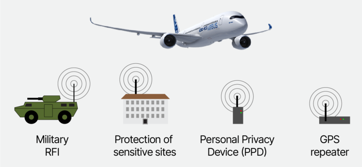
(fig.1) Main sources of GNSS jamming and spoofing
Military activities
Section titled “Military activities”The majority of GNSS RFI events recently observed in-service result from military Electronic Warfare activities in conflict zones or related to the testing of such capabilities. The affected areas are often identified via NOTAMs informing flight crews to expect interference when operating in these areas. However, if such military RFI activities are not identified or communicated in advance, aircraft may be exposed to jamming, spoofing, or both without prior notice.
Protection of sensitive sites and VIPs
Section titled “Protection of sensitive sites and VIPs”Another major source of RFI is the implementation of security measures for sensitive sites and Very Important Persons (VIPs) intentionally interfering with GNSS to counter Unmanned Aerial Vehicles (UAVs). Affected areas typically include airports, locations with dignitaries or political figures, and correctional facilities.
Personal Privacy Devices (PPD)
Section titled “Personal Privacy Devices (PPD)”Personal Privacy Devices (PPDs) intentionally jam GNSS receivers in close proximity, aiming to make tracking devices ineffective. These devices have caused significant operational disruptions at airports when activated in the airportʼs vicinity.
GNSS repeaters
Section titled “GNSS repeaters”GNSS repeaters receive the authentic GNSS signals and re-broadcast (“repeat”) them to enable reception inside buildings, where the GNSS signals would be otherwise masked. If GNSS repeater emissions are not properly managed, they are equivalent to GNSS spoofing, possibly impacting aircraft operating in the vicinity of the repeater.
Several Aircraft Systems Are Affected by GNSS Interference
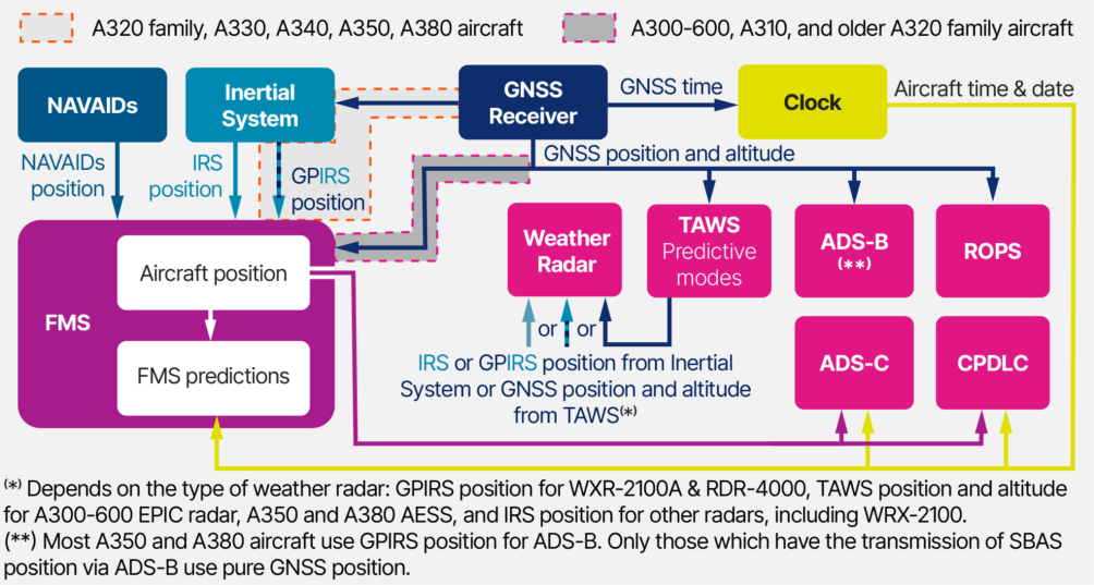
Section titled “Several Aircraft Systems Are Affected by GNSS Interference”There are many direct or indirect users of the GNSS data inside an aircraft. Depending on the aircraft type and the system architecture, the effects of GNSS interference may differ.
(fig.2) Simplified view of the main users of GNSS data on Airbus Aircraft (except A220)
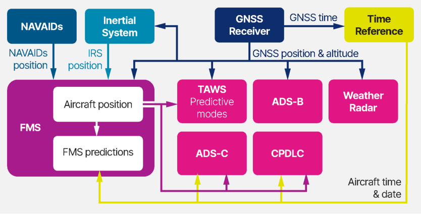
(fig.3) Simplified view of the main users of GNSS data on A220 aircraft
A detailed list of the effects of GNSS RFI on aircraft systems is provided in the following documents:
-
A300, A310, A320 family, A330, A340, A380 aircraft: FCOM - Procedures - Normal Procedures - Supplementary Procedures - GPS interference
-
A350 aircraft: FCOM - Procedures - Normal Procedures - Supplementary Procedures - GNSS interference
-
A220 aircraft: FCOM volume 2 - chapter 03 Normal Procedures - Supplementary procedures - GNSS INTERFERENCE
-
Flight Operations Transmission (FOT) A220-FOT-34-50-002 available on the AirbusWorld portal
-
In–Service Information (ISI) article 34.36.00049 available on the AirbusWorld portal.
EFFECTS OF GNSS RFI ON THE NAVIGATION FUNCTIONS
Section titled “EFFECTS OF GNSS RFI ON THE NAVIGATION FUNCTIONS”Effects of GNSS Jamming (Signal Lost)
Section titled “Effects of GNSS Jamming (Signal Lost)”While GNSS plays a major role in the aircraft positioning system, Airbus aircraft are designed to be robust against the loss of GNSS signals. The use of other data sources (IRS, VOR, and DME) enables the aircraft systems to maintain a position computation capability. A loss of GNSS inputs does not result in a map shift or erroneous position computation by the Flight Management Systems (FMS). In the case of a loss of the GPS signal:
-
A300, A310, A320 family, A330, A340, A350, and A380 aircraft: The FMS (or ADIRS on A350 aircraft) switches from the mixed GPS/IRS position to an IRS-DME/DME position, or IRS-VOR/DME, or pure IRS, in order of priority.
-
A220 aircraft : The FMS switches from the onside GPS to the other sideʼs GPS position, or DME/DME, or VOR/DME, or blended IRS, up to Dead Reckoning, in order of priority.
Refer to the FCOM description of FMS position computation for more detail.
Loss of some navigation capabilities
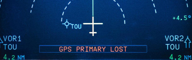
Section titled “Loss of some navigation capabilities”When GPS data is lost, the aircraft position performance may be degraded resulting in an operational impact on Performance Based Navigation (PBN).
Effects of GNSS Spoofing (Erroneous Signal)
Section titled “Effects of GNSS Spoofing (Erroneous Signal)”A300, A310, A320 family, A330, A340, and A380 aircraft
Section titled “A300, A310, A320 family, A330, A340, and A380 aircraft”In the case of GNSS spoofing, the FMS (or ADIRU depending on the aircraft configuration) may not detect that the signal is erroneous , leading to erroneous aircraft position that can be associated to:
-
Unexpected aircraft turn in NAV mode with autopilot engaged
-
Map shift on the Navigation Display
-
Abnormal IR drift information on the POSITION MONITOR page.
In addition, on ground, A300-600 aircraft with EPIC, A320 family, A330, A340, and A380 aircraft may auto-align their IRS to an erroneous GNSS reference.
A350 aircraft
Section titled “A350 aircraft”A350 aircraft position has better robustness against GNSS spoofing due to position hybridization based on both MMR sources and additional position monitoring. In most spoofing events reported to Airbus on A350 aircraft to date, the ADIRU rejected the erroneous GNSS position. However, erroneous aircraft position computation may still occur. At the time of writing the article, one case of erroneous position computation has been confirmed on A350.
On ground, A350 aircraft may also be affected by an automatic IRS alignment to an erroneous GNSS reference.
A220 aircraft
Section titled “A220 aircraft”A220 aircraft can also be affected by erroneous position computation in a spoofing area. The FMS uses GPS as the primary position source. In spoofing conditions resulting in large position shifts, the FMS may reject navaid and IRS positions, leading to an FMS in Dead Reckoning mode.
Additionally, on ground, IRS may also align on an erroneous GNSS reference.
EFFECTS OF GNSS RFI ON THE SURVEILLANCE FUNCTIONS
Section titled “EFFECTS OF GNSS RFI ON THE SURVEILLANCE FUNCTIONS”Effects of GNSS Jamming (Signal Lost)
Section titled “Effects of GNSS Jamming (Signal Lost)”Loss of some surveillance functions
Section titled “Loss of some surveillance functions”Many surveillance functions rely directly on GNSS information. As a consequence, if the GNSS signal is lost, the function may become unavailable. This includes the following (if functions are installed):
-
Predictive Terrain Awareness and Warning System (TAWS)
-
● ADS-B out position reporting ● ADS-B in Air Traffic Situational Awareness (ATSAW), if installed ● Runway Overrun Prevention System (ROPS) ● Altitude Setting Monitoring (ALTSM)
-
TakeOff Surveillance (TOS2) or Takeoff and Landing Awareness Function (TLAF) on A220 aircraft.
Effects of GNSS Spoofing (Erroneous Signal)
Section titled “Effects of GNSS Spoofing (Erroneous Signal)”Possible undue surveillance alerts and erroneous ADS-B position reporting
Section titled “Possible undue surveillance alerts and erroneous ADS-B position reporting”An erroneous GNSS position/altitude may trigger spurious alerts from the following surveillance functions: Predictive TAWS, ROPS, ALTSM, and TakeOff Surveillance (TOS). In addition, the ADS-B position reporting may be erroneous.
Possible loss of the reactive TAWS functions (Honeywell EGPWS and AESS only) and of the TCAS and predictive windshear (AESS only)
Section titled “Possible loss of the reactive TAWS functions (Honeywell EGPWS and AESS only) and of the TCAS and predictive windshear (AESS only)”On A300, A310, A320 family, A330, A340 aircraft equipped with Honeywell EGPWS, or A350, or A380 aircraft, radio altimeter rejection may be caused by an unsuccessful check of its reasonableness, in some specific erroneous GNSS altitude conditions. This results in the loss of the reactive TAWS. Additionally, on A350 and A380 aircraft, this rejection causes the loss of the TCAS and predictive windshear.
Possible impact on the weather radar
Section titled “Possible impact on the weather radar”Weather radars that use GNSS data (A300-600 EPIC radar, WXR 2100A, RDR-4000, and A350 & A380 AESS) can experience display anomalies due to GNSS spoofing. In automatic mode, the terrain database is used to filter ground echoes from the radar display. Consequently, an erroneous position and/or altitude caused by spoofing can lead the radar to misinterpret weather echoes as ground echoes. This results in their removal, or conversely, the display of ground echoes as weather echoes. On aircraft equipped with the Weather Hazard Prediction Function, undue hazard prediction icons may be displayed on the ND. Similarly, undue WEATHER AHEAD messages may be displayed on the ND on radar equipped with the function. In the case of position jumps, the weather radar function may be lost on A350 and A380 aircraft due to an AESS-internal limitation of handling such jumps.
|---|---|---|---|---|---|---|---|---|---|---|---|---|---|---|---|---|---|---|---|---| |||||⬇GNSS signal is lost (jamming)⬇||||||||||||||||| |A380|||||||N/A|||||||||||||| |||||⬇GNSS signal is erroneous (spoofing)⬇||||||||||||||||| |A380|||||||N/A||||||||||||||
(Table 1) Summary of surveillance effects.
EFFECTS OF GNSS RFI ON THE COMMUNICATION FUNCTIONS
Section titled “EFFECTS OF GNSS RFI ON THE COMMUNICATION FUNCTIONS”The table below summarizes the effects that have been identified on communication systems. For more details, the flight crew should refer to the FCOM.
(Table 2) Summary of communications effects.
|---|---|---|---|---|---| |Aircraft type|ADS-C|CPDLC|||SATCOM| |⬇GNSS signal is lost(jamming)⬇|||||| |A300-600(EPIC only)|||||N/A| |A380|||||X| |A350|||||| |⬇GNSS signal is erroneous(spoofing)⬇|||||| |A300-600(EPIC only)|||||N/A| |A380|||||X| |A350||||||
OPERATIONAL CONSIDERATIONS
Section titled “OPERATIONAL CONSIDERATIONS”A dedicated FCOM section provides the procedures to be applied before, within and after a GNSS interference area.
| The procedure for GNSS interference is available in the following documents: | The procedure for GNSS interference is available in the following documents: |
|---|---|
| ● | **A300, A310, A320 family, A330, A340, A380 aircraft:**FCOM - |
| Procedures - Normal Procedures - Supplementary Procedures - GPS | |
| interference | |
| Supplementary Procedures - GNSS interference | |
| ● | **A220 aircraft:**FCOM volume 2 - chapter 03 Normal Procedures - |
| Supplementary procedures - GNSS INTERFERENCE | |
| ● | Additional details about operational considerations related to functional |
| and system effects are provided in the “Flight Operations & Training” tab | |
| of theISI 34.36.00049, available on the AirbusWorld portal (A220 not | |
| covered in this document). |
MAINTENANCE CONSIDERATIONS
Section titled “MAINTENANCE CONSIDERATIONS”Airbus published troubleshooting tasks specifically designed to address GNSS RFI events. It is recommended to perform these tasks after exposure to GNSS interference to clear persistent effects and confirm that system anomalies were indeed caused by GNSS RFI, rather than by a different type of failure.
The troubleshooting tasks can be found in the following documentation:
-
A320 family aircraft: TSM TASK 34-36-00-810-956-A Loss of the GPS/GNSS Function Because of the Interference
-
A330/A340 aircraft: TSM TASK 34-36-00-810-946-A Loss of the GPS/GNSS Function Because of the Interference
-
A350 aircraft: AFI TASK A350-A-34-36-XX-6R001-421A-A Loss of the GPS/GNSS Function Because of the Interference
-
A380 aircraft: TSM TASK 34-36-00-810-858-A Loss of the GPS/GNSS Function Because of the Interference
-
A220 aircraft: COLLINS SIL 523-0834272 “non-volatile memory (NVM) clearing procedure”

TRAINING CONSIDERATIONS
Section titled “TRAINING CONSIDERATIONS”Updated Flight Crew Training Standards (FCTS)
Section titled “Updated Flight Crew Training Standards (FCTS)”Airbus published training recommendations for GNSS interference in the FCTS Annex “Manufacturer Data for EBT” (OTT 999.0027/25 Apr 2025) of all aircraft except A220.
Avoid negative training
Section titled “Avoid negative training”To avoid the risk of negative training, Airbus does not recommend using GNSS Interference scenarios that may lead to undue TAWS alerts in the simulator.
PRODUCT ENHANCEMENTS
Section titled “PRODUCT ENHANCEMENTS”System Enhancements
Section titled “System Enhancements”Airbus is actively participating in industry efforts to address the GNSS interference phenomenon. Ongoing developments include:
Improvement of interference area identification
Section titled “Improvement of interference area identification”As a first step, Airbus is developing a capability to automatically report entry and exit of RFI zones using ACMS and FDM data. The reported data will be shared with flight crews for flight preparation and in-flight awareness.
Spoofing detection implementation and performance improvement of IRS
Section titled “Spoofing detection implementation and performance improvement of IRS”As a second step, enhanced IRS capable of detecting GNSS spoofing will be implemented, offering enhanced performance to maintain a guaranteed level of navigation service.
MMR/GPS receiver, antennas, and TAWS/AESS computer enhancements
Section titled “MMR/GPS receiver, antennas, and TAWS/AESS computer enhancements”In parallel, the development of enhanced receivers, enhanced antennas, and computer standards is ongoing to improve resilience to GNSS interference. This will lead to a reduction in nuisance alerts, minimize the chance of losing surveillance functions, and decrease the likelihood of persistent adverse effects.
Authenticated GNSS signals and spoofing detection within GNSS receivers
Section titled “Authenticated GNSS signals and spoofing detection within GNSS receivers”As a third step, the industry is progressing on authenticating GNSS signals and messages to prevent undetected spoofing. Suppliers are also working on developing GNSS receivers capable of spoofing detection, which prevents the transmission of erroneous signals to the aircraft systems.
Jammertest campaign
Section titled “Jammertest campaign”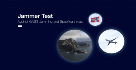
Airbus, in collaboration with other industry actors, participated in the “Jammertest” campaign in Norway, September 15-19, 2025 , to test new technologies against GNSS interference on an A330neo aircraft. The objectives were to evaluate the performance and maturity of innovative technologies proposed by our suppliers, in a controlled jamming and spoofing environment, and to understand the aircraft systemsʼ behavior reported by Airbus operators.
The data collected during the campaign significantly helped the participants in advancing the definition of new solutions to address the phenomenon.
An status of the on-going enhancements is provided in the “Flight Operations & Training” tab the ISI 34.36.00049 , available on the AirbusWorld portal (A220 not covered in this document).
Documentation Enhancements
Section titled “Documentation Enhancements”Airbus regularly updates the FCOM and ISI articles concerning GNSS interference with the latest available information and recommendations. Operators are advised to regularly check these resources for updates. Furthermore, Airbus organizes regular webinars to communicate the latest information.
Contributors:
Section titled “Contributors:”Laurent AZOULAI
Section titled “Laurent AZOULAI”Senior Expert Communication, Navigation & Surveillance
Jean Baptiste DURANCEAU
Section titled “Jean Baptiste DURANCEAU”A220 Avionics Engineering Specialist
Julien FRARD
Section titled “Julien FRARD”A220 Flight Operations Engineer Customer Support
David GARTNER
Section titled “David GARTNER”Head of Surveillance & Vision Sensors Design Office
Laura MARTIN SACRISTAN
Section titled “Laura MARTIN SACRISTAN”Flight Operations Support specialist Customer Support
Stefan SCHWEIGER
Section titled “Stefan SCHWEIGER”Radionavigation & Surveillance In-Service Technical Leader Customer Support
Timo WARNS
Section titled “Timo WARNS”Aircraft Information Security Expert
With thanks to Cedric DESCHEEMAKER from Aviation Safety and Marc LE-LOUER from the Flight Operations Support
Section titled “With thanks to Cedric DESCHEEMAKER from Aviation Safety and Marc LE-LOUER from the Flight Operations Support”GNSS Radio Frequency Interference (RFI) is frequently encountered in some areas of the world, particularly around conflict zones. GNSS RFI includes jamming, which results in the loss of GNSS signals, and spoofing, which provides erroneous signals.
Many aircraft systems rely on GNSS data and may, therefore, be affected by RFI. The resulting impact on aircraft systems varies significantly depending on whether the aircraft is in a GNSS jamming or spoofing area.
Aircraft position computation is generally robust in the case of GNSS jamming due to the reversion to other position sources when the GNSS signals are lost. However, some navigation capabilities may be lost due to the potential degradation of the aircraft position accuracy.
In the case of GNSS spoofing, in some specific conditions and depending on aircraft configuration, the erroneous GNSS data may not be detected. This can result in erroneous aircraft position computation, with unexpected aircraft turns while the autopilot is engaged, and map shifts, as well as abnormal IRS drift.
Many surveillance and communication functions rely directly on GNSS information. Consequently, a loss of GNSS signal generally results in loss of function. In the case of GNSS spoofing, effects may include undue surveillance alerts or degradation of function performance.
The FCOM includes a chapter dedicated to operations in GNSS interference areas, providing a detailed list of cockpit effects and procedures to be applied for all phases of flight.
Airbus published troubleshooting tasks specifically designed to address GNSS RFI events, as well as training recommendations in the Flight Crew Training Standards (FCTS) manual.
Using the benefit of the Jammertest campaign, and in collaboration with the wider industry, Airbus is developing aircraft system enhancements to improve GNSS resilience to RFI. These new features will be progressively implemented as soon as they become available.
Safety first, 2026. Safety first is published by Airbus S.A.S. 1, rond point Maurice Bellonte - 31707 Blagnac Cedex/France.
Editor: Yannick Malinge, SVP Aviation Safety.
Editorial team: Guillaume Estragnat, Javier Martinez Marina, Vanessa Sadi, Eliza Pal, Gwyneth Duggan, Agathe Sanz, Bruno Fargeon.
Photos by Airbus.
GNSS 干扰
Section titled “GNSS 干扰”来源:Airbus Safety First 网址:https://safetyfirst.airbus.com/gnss-interference/ 发布日期:2026-04-24 类别:Flight Ops, Maintenance, galileo, glonass, GPS, GPS PRIMARY LOST, interference, Navigation, position, RFI, satellite PDF:原始 PDF
GNSS 在航空领域的历史可以追溯到 20 世纪 70 年代和 80 年代,当时全球定位系统 (GPS) 正在开发和部署。GPS 于 1995 年达到完全运行能力。此后,民航已广泛采用 GNSS 作为定位、导航和时间服务的主要来源。飞机定位精度的相应提高显著增强了安全性,并使更直接的飞行航路得以使用,从而显著减少了燃油消耗。
射频干扰 (RFI)
Section titled “射频干扰 (RFI)”从太空发送的低功率信号
Section titled “从太空发送的低功率信号”GPS 信号的接收功率极低,相当于从距离地球表面 20,000 多公里的 60W 灯泡接收到的功率。由于这种低功率特性,GPS 信号极易受到任何在飞机附近发射、且工作于 GPS L1 频段(1575.42 MHz ±10 MHz)的设备产生的射频干扰。
故意干扰 GNSS 的行为分为两大类:GNSS 阻塞式干扰和 GNSS 欺骗式干扰。
GNSS 阻塞式干扰
Section titled “GNSS 阻塞式干扰”一种降低 GNSS 接收能力的射频干扰类型。飞机系统使用的 GNSS 数据可能降级或丢失。
GNSS 欺骗式干扰
Section titled “GNSS 欺骗式干扰”一种发射类似 GNSS 信号的射频干扰类型,这些信号可能与真实信号一起被获取和跟踪,或替代真实信号。这可能导致飞机系统使用错误的 GNSS 数据。
干扰和欺骗的主要来源
Section titled “干扰和欺骗的主要来源”
(图 1) GNSS 阻塞式干扰和欺骗式干扰的主要来源
近年来在役观察到的大多数 GNSS RFI 事件均来自冲突地区或与此类能力测试相关的军事电子战活动。受影响区域通常通过 NOTAM 识别,告知飞行机组在上述区域运行时可能遭遇干扰。然而,如果此类军事 RFI 活动事先未被识别或通报,飞机可能在毫无预警的情况下暴露于干扰、欺骗或两者兼有的环境中。
敏感地点和要客的保护
Section titled “敏感地点和要客的保护”另一个主要的 RFI 来源是为敏感地点和要客 (VIP) 实施的安全措施,故意干扰 GNSS 以对抗无人驾驶航空器 (UAV)。受影响区域通常包括机场、有 dignitaries 或政界人士的场所以及惩教设施。
个人隐私设备 (PPD)
Section titled “个人隐私设备 (PPD)”个人隐私设备 (PPD) 故意在近距离阻塞 GNSS 接收器,使追踪设备失效。这些设备在机场附近激活时已造成严重的运营中断。
GNSS 转发器
Section titled “GNSS 转发器”GNSS 转发器接收真实的 GNSS 信号并重新广播(“转发”)这些信号,以实现建筑物内部的接收,而 GNSS 信号在建筑物内部原本会被遮挡。如果 GNSS 转发器的发射未得到妥善管理,其效果等同于 GNSS 欺骗式干扰,可能影响在转发器附近运行的飞机。
多个飞机系统会受到 GNSS 干扰的影响
Section titled “多个飞机系统会受到 GNSS 干扰的影响”飞机内部有许多直接或间接使用 GNSS 数据的用户。根据飞机型号和系统架构的不同,GNSS 干扰的影响也会有所差异。
(图 2) 空客飞机(除 A220 外)GNSS 数据主要用户的简化视图
(图 3) A220 飞机 GNSS 数据主要用户的简化视图
有关 GNSS RFI 对飞机系统影响的详细列表,请参阅以下文件:
-
A300、A310、A320 系列、A330、A340、A380 飞机: FCOM - 程序 - 正常程序 - 补充程序 - GPS 干扰
-
A350 飞机: FCOM - 程序 - 正常程序 - 补充程序 - GNSS 干扰
-
A220 飞机: FCOM 第 2 卷 - 第 03 章 正常程序 - 补充程序 - GNSS 干扰
-
A220 飞行运营传输 (FOT) A220-FOT-34-50-002,可在 AirbusWorld 门户获取
-
在役信息 (ISI) 文章 34.36.00049,可在 AirbusWorld 门户获取。
GNSS RFI 对导航功能的影响
Section titled “GNSS RFI 对导航功能的影响”GNSS 阻塞式干扰的影响(信号丢失)
Section titled “GNSS 阻塞式干扰的影响(信号丢失)”虽然 GNSS 在飞机定位系统中扮演重要角色,但空客飞机的设计能够抵御 GNSS 信号丢失的影响。其他数据源(IRS、VOR 和 DME)的使用使飞机系统能够保持位置计算能力。GNSS 输入的丢失不会导致飞行管理系统 (FMS) 产生地图偏移或错误的位置计算。 在 GPS 信号丢失的情况下:
-
A300、A310、A320 系列、A330、A340、A350 和 A380 飞机: FMS(在 A350 飞机上为 ADIRS)从混合 GPS/IRS 位置切换到 IRS-DME/DME 位置,或 IRS-VOR/DME,或纯 IRS,按优先级顺序切换。
-
A220 飞机: FMS 从同侧 GPS 切换到另一侧 GPS 位置,或 DME/DME,或 VOR/DME,或混合 IRS,直至推算航行,按优先级顺序切换。
有关 FMS 位置计算的更多详情,请参阅 FCOM 中的描述。
部分导航能力丧失
Section titled “部分导航能力丧失”当 GPS 数据丢失时,飞机位置性能可能会降级,从而对基于性能的导航 (PBN) 产生运营影响。
GNSS 欺骗的影响(错误信号)
Section titled “GNSS 欺骗的影响(错误信号)”A300、A310、A320 系列、A330、A340 和 A380 飞机
Section titled “A300、A310、A320 系列、A330、A340 和 A380 飞机”在 GNSS 欺骗的情况下,FMS(或 ADIRU,取决于飞机构型)可能无法检测到信号是错误的,导致飞机位置错误,可能表现为:
-
自动驾驶仪接通时在 NAV 模式下飞机意外转弯
-
导航显示器上的地图偏移
-
位置监控页面上的 IR 漂移信息异常
此外,在地面时,配备 EPIC 的 A300-600 飞机、A320 系列、A330、A340 和 A380 飞机可能将其 IRS 自动对准错误的 GNSS 参考点。
A350 飞机
Section titled “A350 飞机”由于基于多个 MMR 源的位置混合以及额外的位置监控,A350 飞机的位置在抗 GNSS 欺骗方面具有更好的稳健性。在迄今为止向空客报告的 A350 飞机大多数欺骗事件中,ADIRU 拒绝了错误的 GNSS 位置。然而,飞机位置计算仍可能出现错误。在撰写本文时,A350 上已确认发生了一起位置计算错误的情况。
在地面时,A350 飞机也可能受到自动 IRS 对准错误 GNSS 参考点的影响。
A220 飞机
Section titled “A220 飞机”A220 飞机在欺骗区域也可能受到位置计算错误的影响。FMS 使用 GPS 作为主要位置源。在导致较大位置偏移的欺骗条件下,FMS 可能拒绝导航信标和 IRS 位置,导致 FMS 进入推算航行(Dead Reckoning)模式。
此外,在地面时,IRS 也可能对准错误的 GNSS 参考点。
GNSS RFI 对监视功能的影响
Section titled “GNSS RFI 对监视功能的影响”GNSS 干扰的影响(信号丢失)
Section titled “GNSS 干扰的影响(信号丢失)”部分监视功能丢失
Section titled “部分监视功能丢失”许多监视功能直接依赖 GNSS 信息。因此,如果 GNSS 信号丢失,该功能可能变得不可用。包括以下功能(如果已安装):
-
预测地形意识和警告系统(TAWS)
-
● ADS-B 外发位置报告 ● ADS-B 进近空中交通态势感知(ATSAW),如果已安装 ● 跑道冲出防护系统(ROPS) ● 高度设置监控(ALTSM)
-
A220 飞机上的起飞监视(TOS2)或起飞和着陆意识功能(TLAF)。
GNSS 欺骗的影响(错误信号)
Section titled “GNSS 欺骗的影响(错误信号)”可能出现不必要的监视警告和错误的 ADS-B 位置报告
Section titled “可能出现不必要的监视警告和错误的 ADS-B 位置报告”错误的 GNSS 位置/高度可能触发以下监视功能的虚假警告:预测性 TAWS、ROPS、ALTSM 和起飞监视(TOS)。此外,ADS-B 位置报告可能错误。
可能的反应式 TAWS 功能损失(仅限 Honeywell EGPWS 和 AESS)以及 TCAS 和预测性风切变损失(仅限 AESS)
Section titled “可能的反应式 TAWS 功能损失(仅限 Honeywell EGPWS 和 AESS)以及 TCAS 和预测性风切变损失(仅限 AESS)”在配备 Honeywell EGPWS 的 A300、A310、A320 系列、A330、A340 飞机,或 A350 或 A380 飞机上,在某些特定的错误 GNSS 高度条件下,无线电高度表合理性检查失败可能导致无线电高度表被拒绝。这将导致反应式 TAWS 失效。此外,在 A350 和 A380 飞机上,这种拒绝还会导致 TCAS 和预测性风切变失效。
可能对气象雷达的影响
Section titled “可能对气象雷达的影响”使用 GNSS 数据的气象雷达(A300-600 EPIC 雷达、WXR 2100A、RDR-4000 以及 A350 和 A380 AESS)可能因 GNSS 欺骗而出现显示异常。在自动模式下,地形数据库用于过滤雷达显示上的地面回波。因此,由欺骗引起的错误位置和/或高度可能导致雷达将天气回波误判为地面回波。这会导致其被移除,或者相反,将地面回波显示为天气回波。在配备天气危害预测功能的飞机上,不必要的危害预测图标可能显示在导航显示器上。类似地,在配备该功能的雷达上,不必要的 WEATHER AHEAD 信息可能显示在导航显示器上。在位置跳跃的情况下,由于 AESS 处理此类跳跃的内部限制,气象雷达功能可能在 A350 和 A380 飞机上丢失。
|---|---|---|---|---|---|---|---|---|---|---|---|---|---|---|---|---|---|---|---|---| |||||⬇GNSS 信号丢失(干扰)⬇||||||||||||||||| |A380|||||||不适用|||||||||||||| |||||⬇GNSS 信号错误(欺骗)⬇||||||||||||||||| |A380|||||||不适用||||||||||||||
(表 1) 监视影响概述。
GNSS RFI 对通信功能的影响
Section titled “GNSS RFI 对通信功能的影响”下表总结了已确定的通信系统影响。更多详细信息,飞行机组应参阅 FCOM。
(表 2) 通信影响概述。
|---|---|---|---|---|---| |飞机类型|ADS-C|CPDLC|||SATCOM| |⬇GNSS 信号丢失(干扰)⬇|||||| |A300-600(仅 EPIC)|||||不适用| |A380|||||X| |A350|||||| |⬇GNSS 信号错误(欺骗)⬇|||||| |A300-600(仅 EPIC)|||||不适用| |A380|||||X| |A350||||||
操作注意事项
Section titled “操作注意事项”专用 FCOM 部分提供了在 GNSS 干扰区域之前、之内和之后应执行的程序。
| GNSS 干扰程序可在以下文件中获取: | GNSS 干扰程序可在以下文件中获取: |
|---|---|
| ● | **A300、A310、A320 系列、A330、A340、A380 飞机:**FCOM - |
| ● | **A220 飞机:**FCOM 第 2 卷 - 第 03 章 正常程序 - |
| ● | 有关功能和系统影响相关操作注意事项的更多详情,请参阅 ISI 34.36.00049 的”飞行运营与培训”选项卡,可通过 AirbusWorld 门户获取(本文档未涵盖 A220)。 |
维护注意事项
Section titled “维护注意事项”空客发布了专门用于处理 GNSS RFI 事件的故障排除任务。建议在受到 GNSS 干扰后执行这些任务,以清除持续性影响,并确认系统异常确实由 GNSS RFI 引起,而非其他类型的故障。
故障排除任务可在以下文档中找到:
-
A320 系列飞机:TSM TASK 34-36-00-810-956-A 因干扰导致的 GPS/GNSS 功能丧失
-
A330/A340 飞机:TSM TASK 34-36-00-810-946-A 因干扰导致的 GPS/GNSS 功能丧失
-
A350 飞机:AFI TASK A350-A-34-36-XX-6R001-421A-A 因干扰导致的 GPS/GNSS 功能丧失
-
A380 飞机:TSM TASK 34-36-00-810-858-A 因干扰导致的 GPS/GNSS 功能丧失
-
A220 飞机:COLLINS SIL 523-0834272 “非易失性存储器(NVM)清除程序”
培训注意事项
Section titled “培训注意事项”更新的飞行机组培训标准(FCTS)
Section titled “更新的飞行机组培训标准(FCTS)”空客在除 A220 以外的所有飞机的 FCTS 附件“制造商 EBT 数据”(OTT 999.0027/2025 年 4 月 25 日)中发布了 GNSS 干扰培训建议。
避免负向训练
Section titled “避免负向训练”为避免负向训练风险,空客不建议在模拟机中使用可能导致不必要 TAWS 警告的 GNSS 干扰场景。
空客正积极参与行业应对 GNSS 干扰现象的努力。正在进行的开发包括:
干扰区域识别的改进
Section titled “干扰区域识别的改进”作为第一步,空客正在开发一种自动报告 RFI 区域进入和退出的能力,使用 ACMS 和 FDM 数据。所报告的数据将与飞行机组共享,用于飞行准备和飞行中态势感知。
欺骗检测的实施及 IRS 性能提升
Section titled “欺骗检测的实施及 IRS 性能提升”作为第二步,将实施能够检测 GNSS 欺骗的增强型 IRS,提供增强性能以保持有保障的导航服务水平。
MMR/GPS 接收机、天线及 TAWS/AESS 计算机增强
Section titled “MMR/GPS 接收机、天线及 TAWS/AESS 计算机增强”同时,正在开发增强型接收机、增强型天线和计算机标准,以提高对 GNSS 干扰的抵御能力。这将减少误警,最大限度地减少监视功能丢失的可能性,并降低持续不利影响的发生概率。
GNSS 接收机内的认证 GNSS 信号及欺骗检测
Section titled “GNSS 接收机内的认证 GNSS 信号及欺骗检测”作为第三步,业界正在推进 GNSS 信号和消息的认证,以防止未被检测到的欺骗。供应商也在开发具有欺骗检测功能的 GNSS 接收机,以防止向飞机系统传输错误信号。
Jammertest 活动
Section titled “Jammertest 活动”
空客与其他行业参与者合作,于 2025 年 9 月 15 日至 19 日在挪威参加了“A320neo 飞机上的 Jammertest 活动”,以测试应对 GNSS 干扰的新技术。目标是评估供应商提出的创新技术的性能和成熟度,在受控干扰和欺骗环境中进行测试,并了解空客运营商报告的飞机系统行为。
活动期间收集的数据极大地帮助了参与者推进新解决方案的定义,以应对这一现象。
正在进行的改进状态可在 AirbusWorld 门户上“飞行运营与培训”选项卡中的 ISI 34.36.00049 中获取(本文档未涵盖 A220)。
空客定期更新有关 GNSS 干扰的 FCOM 和 ISI 文章,提供最新可用信息和建议。建议运营商定期查阅这些资源以获取更新。此外,空客定期组织网络研讨会,传达最新信息。
Laurent AZOULAI
Section titled “Laurent AZOULAI”高级通信、导航与监视专家
Jean Baptiste DURANCEAU
Section titled “Jean Baptiste DURANCEAU”A220 航电工程专家
Julien FRARD
Section titled “Julien FRARD”A220 飞行运营工程师客户支持
David GARTNER
Section titled “David GARTNER”监视与视觉传感器设计室主任
Laura MARTIN SACRISTAN
Section titled “Laura MARTIN SACRISTAN”飞行运营支持专家客户支持
Stefan SCHWEIGER
Section titled “Stefan SCHWEIGER”无线电导航与监视在役技术负责人客户支持
Timo WARNS
Section titled “Timo WARNS”飞机信息安全专家
特别感谢来自航空安全的 Cedric DESCHEEMAKER 以及飞行运营支持的 Marc LE-LOUER
Section titled “特别感谢来自航空安全的 Cedric DESCHEEMAKER 以及飞行运营支持的 Marc LE-LOUER”GNSS 射频干扰(RFI)在世界某些地区频繁遭遇,特别是在冲突区域附近。GNSS RFI 包括干扰(Jamming),导致 GNSS 信号丢失;以及欺骗(Spoofing),提供错误信号。
许多飞机系统依赖 GNSS 数据,因此可能受到 RFI 的影响。飞机系统受到的影响程度因飞机处于 GNSS 干扰区还是欺骗区而存在显著差异。
在 GNSS 干扰的情况下,由于 GNSS 信号丢失时会回退到其他位置源,飞机位置计算通常较为稳健。然而,由于飞机位置精度可能下降,某些导航能力可能丧失。
在 GNSS 欺骗的情况下,在某些特定条件下并取决于飞机构型,错误的 GNSS 数据可能未被检测到。这可能导致飞机位置计算错误,在自动驾驶仪接通时出现意外的飞机转弯,以及地图漂移,并伴随 IRS 异常漂移。
许多监视和通信功能直接依赖 GNSS 信息。因此,GNSS 信号丢失通常会导致功能丧失。在 GNSS 欺骗的情况下,影响可能包括不当的监视警告或功能性能下降。
FCOM 包含专门针对 GNSS 干扰区域运行的章节,提供详细的驾驶舱效应列表以及飞行各阶段应遵循的程序。
空客发布了专门针对 GNSS RFI 事件的故障排除任务,以及《飞行机组培训标准》(FCTS)手册中的培训建议。
利用 Jammertest 活动的成果,空客正在与更广泛的行业合作开发飞机系统增强功能,以提高 GNSS 对 RFI 的抗干扰能力。这些新功能将在可用时逐步实施。
Safety first,2026 年。Safety first 由空中客车股份有限公司出版。地址:法国,31707 Blagnac Cedex,Maurice Bellonte 一号环岛。
编辑:Yannick Malinge,航空安全高级副总裁。
编辑团队:Guillaume Estragnat、Javier Martinez Marina、Vanessa Sadi、Eliza Pal、Gwyneth Duggan、Agathe Sanz、Bruno Fargeon。
照片由空客提供。