Terrain Awareness and Warning Systems operations based on GPS data
Source: Airbus Safety First URL: https://safetyfirst.airbus.com/terrain-awareness-and-warning-systems-operations-based-on-gps-data/ Published: 2007-06-29 Magazine Issue: 2017-06 Category: Archive PDF: Original PDF
Dimitri CARSTENSEN Surveillance Systems Engineer
1 Introduction
Section titled “1 Introduction”The following article is giving comprehensive information on the Airbus policy promoting the use of GPS data for TAWS operations. This subject was introduced for the first time in Safety First #1 (January 2005) through the article titled “ GoArounds at Addis Ababa due to VOR Reception Problems ”.
The two TAWS systems proposed by Airbus, EGPWS and T[2] CAS, were originally coupled to the Flight Management computer to gather aircraft position and navigation data. The FM system is using data originating from multiple sources (GPS, IR from ADIRU, Navaids such as VOR, DME, …) to compute the aircraft position.
Experience has shown that FM and ADIRU data could be affected by improper IR alignments, erroneous Navaids or improper ADR barometric settings. These could lead to TAWS spurious alerts and unnecessary go-around procedures during approach and landing phases.
2 Basic principles of the new TAWS + GPS architecture :
Section titled “2 Basic principles of the new TAWS + GPS architecture :”The new TAWS architecture is based on the use of a GPS sensor (Multi Mode Receiver or GPS Stand-alone Unit) linked to the TAWS computer.
Indeed, with this GPS based architecture, TAWS performance is improved due to the better accuracy of GPS information compared to FM and ADIRU data. The segregation of the surveillance aircraft positioning data channel from the navigation channel ensures a full independence between these two major avionics functions.
The GPS is linked either directly (Autonomous configuration - ) or through the ADIRU 1 (Hybrid configuration – most common on Airbus aircraft). In the latter configuration The ADIRU 1 is not interacting on the GPS data delivered to the TAWS computer, it is only used as a pass-through media.
Consequently, Airbus developed new TAWS architectures where the TAWS computer takes the aircraft position data directly from the GPS sensor.
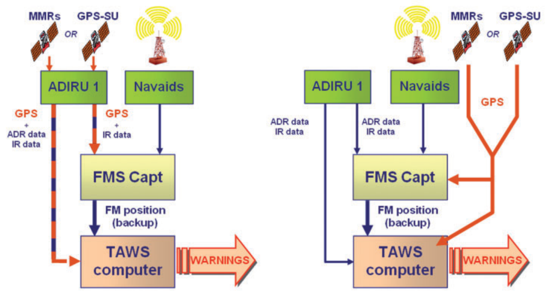
Hybrid architecture Most commonly used on Airbus (ADIRU 4MCU)
Autonomous Architecture Previously used on Airbus (ADIRU 10MCU)
The TAWS computer uses the GPS data for positioning the aircraft in the three dimensions:
-
l The latitude and longitude data are used to position the aircraft relative to the TAWS Terrain Database (EGPWS and T[2] CAS). This can be easily implemented on the aircraft by activating the corresponding functions on the TAWS computers by simple pin programming. These functions are named “Use of GPS for Lateral positioning” on EGPWS, and “Alternate Lateral Position based on GPS” for T[2] CAS.
-
l The altitude data is used to compute a “Geometric Altitude” (EGPWS) also called “Alternate Vertical position based on GPS” (T[2] CAS), which is a blend of the Barometric altitude, Radio Altitude, terrain and runway elevation data to ensure optimal performance of the Basic and Terrain functions of the TAWS computer.
As above, these functions can be easily activated on aircraft by a simple pin programming of the TAWS computer.
In addition, when GPS data are used for latitude and longitude, the TAWS computer is modified by pin programming to perform an automatic management of the Terrain functions. This management is based on the availability and precision of the different position sources (by order of priority: GPS, IR from ADIRU, FM Computer).
When these position sources are neither available, nor precise enough, the TAWS computer automatically deactivates its Terrain functions. Previous deactivation had to be performed manually with the possible consequence, in case of omission, of potential spurious Terrain warnings during the approach and landing phases.
Note: In case of the Terrain function deactivation, basic TAWS Reactive Modes 1 to 5 remain fully operative.
3 Implementation for the EGPWS Computer (Honeywell) :
Section titled “3 Implementation for the EGPWS Computer (Honeywell) :”Airbus has certified the new Honeywell EGPWS P/N 965-1676-002 for the direct use of GPS data, either in Hybrid or Autonomous configuration. The EGPWS P/N 965-1676-002 can be installed in place of previous EGPWS versions, on all Airbus aircraft.
In addition to the use of GPS data for latitude/ longitude positioning and activation of the geometric altitude, P/N 965-1676-002 also provides the availability of Peaks and Obstacles functions for all Airbus aircraft equipped whether with EIS1 (CRT) or EIS2 (LCD) display systems.
The Obstacles function enables the EGPWS to alert the crew of possible collision with man-made obstacles. The Peaks function enables the display of the terrain with the elevation being relative to the Mean Sea Level (MSL).
The green number in the lower right corner of the display features the lowest terrain altitude. The red number, just above, indicates the altitude of the highest obstacle.
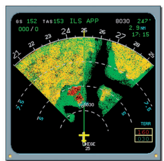
Peaks & Obs display
This new EGPWS will enable a fleet wide Part Number commonality whatever the aircraft configuration, resulting in a noticeable operational benefit.
Airbus has developed a set of Standard Service Bulletins for installing EGPWS P/N 965-1676-002 and activating the GPS data based functions. These Standard Service Bulletins are covering every Airbus aircraft and have been sent to every operator having aircraft already equipped with EGPWS P/N 965-0976-003-206-206 or P/N 9651676-001.
In production, the TAWS + GPS architecture on EGPWS equipped aircraft has been standardized since January 2006.
Please refer to OIT ref. SE 999.0050/06/VHR datedPlease refer to OIT ref. SE 999.0050/06/VHR 18 April 2006.dated 18 April 2006. Please refer to SIL 34-080 rev.06 (March 2007)Please refer to SIL 34-080 rev.06 (March 2007).
4 Implementation for the T[2] CAS Computer (ACSS)
Section titled “4 Implementation for the T[2] CAS Computer (ACSS)”The “Alternate Lateral Position based on GPS” and “Alternate Vertical position based on GPS” functions can be easily activated through pin programming on T[2] CAS Standard 1 P/N 90000010110 and future Standard 2 P/N 900000-11111 (certification obtained in April 07), on every Airbus aircraft.
Airbus has developed a set of Standard Service Bulletins for the activation of these GPS data based functions. These Standard Service Bulletins are covering all Airbus aircraft families and have been sent to all operators using aircraft already equipped with T[2] CAS Standard 1 P/N 900000-10110.
In production, the TAWS + GPS architecture on T[2] CAS equipped aircraft has been standardized since May 2005.
Please refer to OIT ref. SE 999.0034/07/VHR DatedPlease refer to OIT ref. SE 999.0034/07/VHR 13 March 2007.Dated 13 March 2007. Please refer to SIL 34-080 rev.06 (March 2007).Please refer to SIL 34-080 rev.06 (March 2007).
5 R lar te of egu upda the TAWS database
Section titled “5 R lar te of egu upda the TAWS database”TAWS operations are based on the use of a terrain database. This database must be kept updated regularly to the latest version to obtain the full operational and safety benefits of TAWS operations.
Please refer to SIL 34-080 for more informationPlease refer to SIL 34-080 for more information on the terrain Database and its associatedon the terrain Database and its associated downloading procedure. downloading procedure.
6 Conclusion
Section titled “6 Conclusion”Errors in the aircraft position provided by the Flight Management computer to the TAWS system may lead to spurious alerts and unnecessary goarounds.
Airbus has therefore developed a new system architecture, which links the TAWS computer directly to the GPS. This solution is easy to retrofit and improves the performance of the system.
Please refer to SIL 34-080 rev. 06 (March 2007) Please refer to SIL 34-080 rev. 06 (March 2007) to find the applicable Standard Service Bulletins to find the applicable Standard Service Bulletins for your aircraft fleet. for your aircraft fleet.
For more information about FM map shifts scenarios For more information about FM map shifts and root causes analysis, please refer to SIL 22043.scenarios and root causes analysis, please refer to SIL 22-043.
The Airbus Policy promoting this new TAWS system architecture based on GPS data is given in OIT/FOTThe Airbus Policy promoting this new TAWS ref. SEE999.0015/04/VHR dated 05 Feb 2004. system architecture based on GPS data is given in OIT/FOT ref. SEE999.0015/04/VHR dated 05 Feb 2004.
Dimitri CARSTENSEN 监视系统工程师
本文旨在提供空客关于推广使用 GPS 数据进行 TAWS 运行的政策的全面信息。该主题首次在《Safety First》第1期(2005年1月)发表的文章《Addis Ababa 因 VOR 接收问题导致的复飞》中提出。
空客提出的两种 TAWS 系统——EGPWS 和 T²CAS,最初耦合至飞行管理计算机以获取飞机位置和导航数据。FM 系统使用来自多个源的数据(GPS、来自 ADIRU 的 IR、VOR 和 DME 等导航设备)来计算飞机位置。
经验表明,FM 和 ADIRU 数据可能受惯性基准校准不当、导航设备信号错误或 ADR 气压设置不正确的影响。这可能导致 TAWS 虚假警告以及在进近和着陆阶段不必要的复飞程序。
2 新型 TAWS + GPS 架构的基本原理
Section titled “2 新型 TAWS + GPS 架构的基本原理”新型 TAWS 架构基于使用 GPS 传感器(多模式接收机 MMR 或 GPS 独立单元)连接到 TAWS 计算机。
事实上,基于 GPS 的架构可改善 TAWS 性能,因为与 FM 和 ADIRU 数据相比,GPS 信息的精度更高。监视飞机定位数据通道与导航通道的分离确保了这两大航电功能之间的完全独立性。
GPS 可直接连接(自主构型),也可通过 ADIRU 1 连接(混合构型——空客飞机最常用)。在后一种构型中,ADIRU 1 不对传递给 TAWS 计算机的 GPS 数据产生影响,仅作为传输介质使用。
因此,空客开发了新型 TAWS 架构,TAWS 计算机直接从 GPS 传感器获取飞机位置数据。
混合架构 空客最常用(ADIRU 4MCU)
自主架构 空客先前使用(ADIRU 10MCU)
TAWS 计算机使用 GPS 数据在三个维度定位飞机:
-
l 纬度与经度数据用于将飞机相对于 TAWS 地形数据库(EGPWS 和 T²CAS)进行定位。这可以通过简单引脚编程激活 TAWS 计算机上的相应功能来轻松实现。这些功能在 EGPWS 上称为“Use of GPS for Lateral positioning”(使用 GPS 进行横向定位),在 T²CAS 上称为“Alternate Lateral Position based on GPS”(基于 GPS 的备用横向位置)。
-
l 高度数据用于计算“几何高度”(EGPWS),也称为“基于 GPS 的备用垂直位置”(T²CAS)。该数据是气压高度、无线电高度、地形及跑道标高的融合,以确保 TAWS 计算机基本功能和地形功能的最佳性能。
如上所述,这些功能可通过简单引脚编程在飞机上轻松激活。
此外,当 GPS 数据用于纬度和经度时,TAWS 计算机通过引脚编程修改为自动管理地形功能。该管理基于不同位置源的可用性和精度(按优先级排序:GPS、来自 ADIRU 的 IR、FM 计算机)。
当这些位置源既不可用也不足够精确时,TAWS 计算机自动停用其地形功能。先前的停用必须手动执行,可能因遗漏而导致进近和着陆阶段潜在的虚假地形警告。
注:当地形功能停用时,基本 TAWS 反应模式 1 至 5 保持完全运行。
3 EGPWS计算机(霍尼韦尔)的实施:
Section titled “3 EGPWS计算机(霍尼韦尔)的实施:”空客已为件号965-1676-002的新型霍尼韦尔EGPWS取得认证,可直接使用GPS数据,采用混合配置或自主配置。该EGPWS P/N 965-1676-002可安装在所有空客飞机的相应位置,替代先前版本的EGPWS。
除使用GPS数据进行纬度/经度定位及几何高度激活功能外,P/N 965-1676-002还为所有装备EIS1(CRT)或EIS2(LCD)显示系统的空客飞机提供地形峰值(Peaks)和障碍物(Obstacles)功能。
障碍物功能使EGPWS能够警告机组可能与人工障碍物发生碰撞。地形峰值功能使地形显示的高程以平均海平面(MSL)为基准。
显示屏右下角的绿色数字显示最低地形高度。紧邻其上方的红色数字表示最高障碍物的高度。
地形峰值与障碍物显示
此新型EGPWS将使整个机队在任何飞机配置下实现件号统一,带来显著运营效益。
空客已制定一套标准服务通告,用于安装EGPWS P/N 965-1676-002及激活基于GPS数据的功能。这些标准服务通告覆盖所有空客飞机,并已发送给所有已装备EGPWS P/N 965-0976-003-206-206或P/N 9651676-001的运营商。
在生产方面,自2006年1月起,已对装备EGPWS飞机的TAWS + GPS架构进行了标准化。
请参阅2006年4月18日发布的OIT参考文件SE 999.0050/06/VHR。请参阅SIL 34-080 rev.06(2007年3月)。
4 TCAS计算机(ACSS)的实施
Section titled “4 TCAS计算机(ACSS)的实施”“基于GPS的备用横向位置”和“基于GPS的备用垂直位置”功能可通过针脚编程轻松激活,适用于T[C]AS标准1 P/N 90000010110及未来标准2 P/N 900000-11111(2007年4月取得认证),覆盖所有空客飞机。
空客已制定一套标准服务通告,用于激活这些基于GPS数据的功能。这些标准服务通告覆盖所有空客飞机系列,并已发送给所有使用已装备T[C]AS标准1 P/N 900000-10110飞机的运营商。
在生产方面,自2005年5月起,已对装备T[C]AS飞机的TAWS + GPS架构进行了标准化。
请参阅2007年3月13日发布的OIT参考文件SE 999.0034/07/VHR。请参阅SIL 34-080 rev.06(2007年3月)。
5 TAWS数据库更新频率
Section titled “5 TAWS数据库更新频率”TAWS运行基于地形数据库的使用。该数据库必须定期更新至最新版本,以获得TAWS运行的全部运营和安全效益。
请参阅SIL 34-080,了解地形数据库及其相关下载程序的更多信息。
飞行管理计算机向TAWS系统提供的飞机位置误差可能导致虚假警告和不必要的复飞。
因此,空客开发了一种新系统架构,将TAWS计算机直接与GPS相连。该解决方案易于改装,并可提高系统性能。
请参阅SIL 34-080 rev. 06(2007年3月),了解适用于贵机队的相关标准服务通告。
有关FM地图偏移场景及根本原因分析的更多信息,请参阅SIL 22-043。
空客推广此基于GPS数据的新TAWS系统架构的政策见OIT/FOT参考文件SEE999.0015/04/VHR,日期为2004年2月5日。