Go-Arounds at Addis Ababa due VOR Reception Problems
Source: Airbus Safety First URL: https://safetyfirst.airbus.com/go-arounds-at-addis-ababa-due-vor-reception-problems/ Published: 2005-01-27 Category: Archive PDF: Original PDF

By: Jean Daney Director of Flight Safety As reported by an Airbus Operator and reproduced with their permission
The following article was provided by the involved Airbus operator and has been reproduced with their agreement but has been de-identified. At the end of the article there is information on the Airbus policy concerning the use of GPS position for Terrain Awareness and Warning System (TAWS). This policy was issued in an OIT/FOT (ref: SE 999.0015/04/VHR dated 05 February 2004).
The same crew and aircraft had been scheduled to operate the flight from **** to Addis Ababa Bole Airport (HAAB) with a single en-route stop at****.
started fluctuating during the descent and eventually the indications disappeared. With no adequate visual reference, a standard missed approach was flown from a minimum altitude of 8922’ amsl and the aircraft entered the hold over the ADS. Once in the hold and after confirming with Bole ATC that the VOR/DME was serviceable the crew carried out a navigation accuracy check that appeared normal and elected to carry out a further approach. Once again, the VOR indication fluctuated during the inbound leg and another missed approach was flown from a minimum altitude of 8866’ amsl after which the aircraft diverted to Djibouti. A brief EGPWS “Terrain Ahead” warning occurred as the go-around was initiated.
The first sector was operated without incident and, after disembarking passengers and refuelling, continued to HAAB. On arrival overhead the Addis Ababa VOR/DME (ADS 112.90 MHz), the flight was cleared to carry out a standard VOR/DME approach to runway 25L at Bole. Touchdown elevation at Bole was 7593’ amsl and the MDA for the procedure 8020’ amsl. There were no civilian radar facilities.
The VOR/DME indications had appeared normal up to the start of the procedure, but during the outbound leg, ADS 092° radial, an unexpected large correction left was required to acquire the radial. After flying the ADS DME 13nm arc, a left turn was made to intercept the 249° inbound QDM and descent from 11200’ amsl commenced in accordance with the procedure. The VOR radial
After refuelling at Djibouti, the commander elected to use his discretion to extend the flying duty period and return to HAAB. On arrival at Bole, a daylight visual approach was flown to runway 25L and a successful landing made. It was noted during this approach that the VOR bearing information was in error up to 30° and that any attempt to fly the procedural inbound QDM would have displaced the aircraft to the North of the required track.
The commander filed an Air Safety Report (ASR) as required by the company in the event of any go-around. Normal company procedures also required an inspection of flight data from the Quick Access Recorder (QAR) as part of the follow up to any ASR and the company Flight Safety Manager carried this out.
Safety first #01 January 2005 - 1
The analysis revealed that at some point on both approaches the aircraft had passed over a ridge of high ground not normally encountered on the 25L approach. At the point at which the second go-around had been initiated the aircraft had passed over the ridge with a clearance of 55’ as shown by the radio altimeter recording. At no time were the crew aware of this close proximity to the ground.
A full company investigation into the circumstances of the incident continued independently of the official investigations initiated by the state authorities concerned and with the assistance of the Airbus Flight Safety Department. Following the outcome of the company investigation, the company has put in place measures to minimise the risk of similar incidents which include:
-
HAAB to be treated as a Category ‘C’ airport,
-
Operations to HAAB to be conducted by GPS equipped aircraft only,
-
Approach to be discontinued if VOR indications differ from GPS derived FMGS indications by more than 5°,
-
The MDA for the 25L VOR/DME procedure raised to 9380’ amsl (1790’ aal) in association with a minimum visibility of 5KM,
-
Approach to be discontinued if no visual contact with the runway approach lights at ADS DME 5nm (FAF). (ie MAP is ADS 5DME)
Note: The last two restrictions have since been relaxed as confidence in the “ADS VORDME was regained. The airport authorities have also installed an ILS on this runway and a new DVORDME facility in the area since this incident took place.
The incident aircraft has also been fitted with a GPS engine in the EGPWS computer as an interim measure, with a full GPS MMR upgrade scheduled for early 2005.
Navigational Considerations
Section titled “Navigational Considerations”All Airbus A320 aircraft are fitted with triple Inertial Reference Systems (IRS). The navigation function is performed by the dual Flight Management & Guidance Computers using the outputs from the IRS and refining the combined IRS position with radio navigation aid or GPS satellite information. The involved aircraft is not fitted with GPS satellite navigation equipment and the position refinement is taken from ground radio navigation aids only, typically DME/DME, VOR/DME or VOR/VOR crosscuts depending on local availability.
In the area of Addis Ababa the only suitable radio navigation aid was the “ADS” VOR/DME located between the two runways at Bole Airport at position N08 58.7 E038 47.9. It follows, therefore, that any error in the transmitted data from this VOR would result in a corresponding error in the computed FMGC position. Such errors could result from faulty operation of the VOR/DME facility, radio frequency interference with the transmitted data or anomalous radiation caused by local terrain (sometimes referred to as “scalloping”).
The possibility of faulty airborne equipment had to be considered but this is unlikely as similar anomalous VOR indication behaviour was observed during a subsequent approach by another A320 fitted with a GPS. This latter occurrence was witnessed by the Flight Safety Manager.
The incident was discussed with the Director of the Air Operations and Navigational Aids Department (DONAD) and the Head of Safety Investigations of the Ethiopian CAA. The former stated that he was not aware of any other reports of problems with the ADS VOR but that an investigation would be carried out in response to this particular report. On the following day a verbal report was received that an examination
Safety first #01 January 2005 - 2
of the VOR transmitter had revealed a 2°error in the radiation pattern and that an alternative transmitter was in service. Calibration of the alternative transmitter appeared to have been by pilot report from GPS equipped inbound aircraft and it was stated that the pattern was correct.
At a subsequent meeting with the Flight Safety Officer of Ethiopian Airways it was stated that there had been concerns from Ethiopian Airways pilots that the inbound leg of the 25L VOR/DME procedure was “taking aircraft too far north of the ideal track”. It was not clear whether these concerns had been relayed to the Ethiopian CAA, although it was stated that Ethiopian Airlines was putting pressure on the CAA too install an ILS for this runway prior to the rainy season that starts around July/August.
The following day, the company Flight Safety Manager was subsequently contacted by Bole ATC and advised that the ADS VOR had been taken out of service following a fault caused by the heavy rain that had occurred during that evening. The company flight for that day had already departed and was diverted to Khartoum. A further call from Bole ATC confirmed that the VOR was back in service and fully serviceable. The diverted flight arrived at HAAB with no reported problems.
Addis Ababa Bole International Airport (HAAB)
Section titled “Addis Ababa Bole International Airport (HAAB)”The airport has been undergoing significant development in recent years and has recently seen the construction of a new terminal building and the new 07R/25L runway. The new runway lays parallel to and approximately 400m south of the original 07L/25R. The ADS VOR was moved to its current location south of the two runways during the development.
In current operations 07R/25L is used as the main runway with the old runway designated as taxiway “Foxtrot”. However, 07L/25R is still used as an active runway by local traffic.
The only instrument approach procedures currently available to the operator at the time were the VOR/DME procedures for 25L and 25R. Landings on runway 07R are achieved by carrying out the 25L VOR/DME procedure and breaking left for a visual circling approach to 07R. The Ethiopian CAA has promulgated a GPS/RNAV procedure for runway 07R and will shortly promulgate one for 25L. The involved operator does not currently hold an approval for GPS/RNAV approaches. Full ILS procedures for both 25L and 25R are now promulgated.
In addition to the ADS VOR, there were two MF locator beacons, ‘AB’ 333 KHz and ‘BL’ 352 KHz, situated on the original ILS approach path to 25R. There were no ILS procedures promulgated for the airport at the time, although the original 25R ILS localiser was believed to be still radiating on 110.3 MHz. New aids have now been installed as stated above.
Bole Airport is located on the south western outskirts of the city of Addis Ababa, Ethiopia. The airport reference co-ordinates shown on the EAG Aerad chart are: N08 58.7 E038 47.9
Addis Ababa is situated on the Ethiopian plateau at an elevation of 7600’ amsl and is surrounded by areas of high ground rising to approximately 11000’ amsl.
Safety first #01 January 2005 - 3
Terrain Considerations
Section titled “Terrain Considerations”The airport is situated on a relatively flat plain at 7600’ amsl. The level of the plain rises gradually to the east attaining an elevation of approximately 8500’amsl 15nm from the airport. There are significant high peaks around the airport as follows:
-
10535’ amsl 010°T / 8nm Bearings and distances are approximate
-
• 9646’amsl 025°T / 11nm from VOR/DME position
-
• 10167’ amsl 120°T / 11.5nm • 9200’ amsl 230°T / 9nm
There is a significant ridge running approximately 135°T from the first of the above peaks and running out into the plain at about 6nm from the VOR. This ridge is the one referred to in later sections of this report. A further ridge runs approximately 215°T from the same peak towards the eastern outskirts of the city. This runs out into the plain approximately 3.5nm north of the airport.
Terrain information is provided for the crew by the following:
• EAG Aerad charts N1/N2
these show “safety contours” and Sector Safe Altitudes for the four prime sectors within 25nm of the aerodrome reference point. At Addis, the SSA for all sectors is shown as 13500’. No detailed terrain information is shown.
• EAG Aerad Terrain Chart
A large scale chart showing the main features in a large area around Addis. No fine detail of terrain around the airport is shown.
• Military ONC Chart
Section titled “• Military ONC Chart”A 1:1000000 scale chart of the region
The involved aircraft is fitted with a Honeywell Enhanced Ground Proximity Warning System (EGPWS) with software to standard 428. The EGPWS computer has been removed from the aircraft and an attempt made to download event data from it. This was initially unsuccessful due to a fault condition at the time of removal. The unit was returned to the OEM who achieved a download in his workshop. During the subject approaches and go-arounds the crew heard only one EGPWS alert, a “Too Low Terrain” call just after initiation of the second go-around believed to have been triggered by the Terrain Clearance Floor mode. The QAR recorded a short duration Mode 4 ”Too Low Terrain” warning at about the same time.
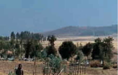
This photograph shows the NW to SE ridge running down towards the approach path. It was taken from near the village of Leghedadi 10nm NW of the airport looking WSW from a range of approximately 5nm.

This picture shows the same ridge from a range of about 8nm from the NW of Leghedadi.
Safety first #01 January 2005 - 4
Terrain Profiles
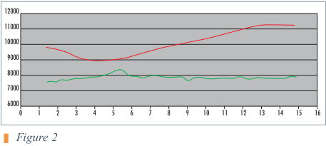
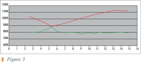
Section titled “Terrain Profiles”The following approach and terrain profiles were derived using the data from the QAR. The pressure altitudes recorded have been corrected for a QNH of 1027 HPa for Figure 1 and 1029 HPa for Figures 2 & 3.
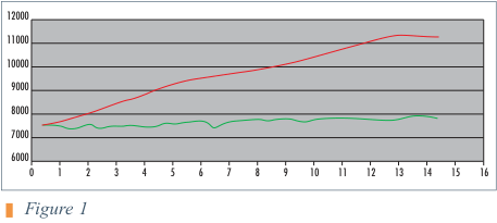
The distance scale on this figure can be directly related to DME distance from the “ADS”. In Figures 2 & 3, the 13nm marker can be taken as 13D from the “ADS”, but other distances do not relate to DME as the aircraft was not flying towards the DME facility. The distances have been corrected to take account of the varying groundspeed during each approach.
Aircraft Position
Section titled “Aircraft Position”The only position information available from the QAR was the recorded FMGC latitude and longitude. Since the FMGC position was IRS position corrected by radio position and the only radio position was based on the suspect VOR/DME facility, no reliance can be placed on the accuracy of the recorded position information.
One point of interest was the behaviour of the recorded FMGC position immediately after each go-around. The standard missed approach procedure for the 25L VOR/DME approach states “Left (max 185kt) as soon as practicable onto ADS 193R to 13500 5910 then right to ADS and hold or as directed”. (EAG Aerad Chart N1 dated 20 FEB 03). On both go-arounds the recorded heading information suggests that the aircraft followed this procedure. The FMGC position data, however, indicates a right turn immediately after each go-around followed later by an abrupt left turn onto a southerly track. The crew report stated that during each approach the VOR indications were lost just prior to the go-around, but came back as the go-around proceeded. During the approach made by the GPS fitted aircraft the following behaviour was observed:
来源:Airbus Safety First 网址:https://safetyfirst.airbus.com/go-arounds-at-addis-ababa-due-vor-reception-problems/ 发布日期:2005-01-27 类别:档案 PDF:原始PDF
作者:Jean Daney 飞行安全总监 由空中客车一家运营商报告并经其许可转载
以下文章由相关空中客车运营商提供,经其同意后转载,但已做去标识化处理。文章末尾提供了有关GPS位置用于地形意识与警告系统(TAWS)的空中客车政策信息。该政策于2004年2月5日发布于OIT/FOT(编号:SE 999.0015/04/VHR)。
同一机组和飞机原计划执行从至亚的斯亚贝巴博莱机场(HAAB)的航班,经进行一次中途经停。
在下降过程中,VOR/DME指示开始波动,最终信号消失。由于没有足够的目视参考,飞机从最低高度8922′ amsl执行了标准复飞,并在ADS上空进入等待。进入等待后,经与博莱ATC确认VOR/DME可用,机组进行了导航精度检查,结果显示正常,随后决定再次进近。在进近的向台航段,VOR指示再次出现波动,飞机从最低高度8866′ amsl再次执行复飞,随后备降吉布提。复飞开始时出现了短暂的EGPWS“前方地形”警告。
第一航段正常执行,在下客和加油后,继续飞往HAAB。到达亚的斯亚贝巴VOR/DME(ADS 112.90 MHz)上空后,飞机获准执行标准VOR/DME进近至博莱25L号跑道。博莱的触地标高为7593′ amsl,进近程序的最低下降高度(MDA)为8020′ amsl。该地区没有民用雷达设施。
VOR/DME指示在程序开始前显示正常,但在出港航段(ADS 092°径向线)时,需要出乎意料的大幅度向左修正才能截获该径向线。飞完ADS DME 13nm弧线后,向左转弯切入249°向台QDM,并按照程序从11200′ amsl开始下降。VOR径向线
在吉布提加油后,机长决定酌情延长飞行执勤期并返回HAAB。抵达博莱后,执行了日间目视进近至25L号跑道,并成功着陆。在此进近过程中,注意到VOR方位信息偏差高达30°,任何按照程序向台QDM飞行的尝试都会使飞机偏离至所需航道的北侧。
机长按照公司规定提交了航空安全报告(ASR),触发条件为任何复飞。公司正常程序还要求对任何ASR的后续处理中检查快速访问记录器(QAR)的飞行数据,公司飞行安全经理执行了此项工作。
Safety First #01 2005年1月 - 1
分析显示,在两次进近的某个时刻,飞机均飞越了一片通常在25L进近中不会遇到的高地山脊。在第二次复飞发起时,飞机已飞越该山脊,无线电高度表记录显示最小余度为55′。机组对此与地面的接近情况毫不知情。
公司对该事件情况的全面调查独立于有关国家当局启动的官方调查进行,并获得了空中客车飞行安全部的协助。根据公司调查结果,公司已采取以下措施以最大程度降低类似事件的风险:
- 将HAAB作为C类机场对待,
- 仅允许配备GPS的飞机执行飞往HAAB的运营,
- 如VOR指示与GPS推导的FMGS指示相差超过5°,应中断进近,
- 将25L VOR/DME程序的MDA提高至9380′ amsl(1790′ aal),同时要求最低能见度为5公里,
- 如在ADS DME 5nm(FAF)处仍未目视接触跑道进近灯,应中断进近(即复飞点为ADS 5 DME)。
注:最后两项限制此后已放宽,因为对“ADS VOR/DME的信心已恢复。事件发生后,机场当局还在该跑道安装了ILS,并在该地区安装了新的DVOR/DME设施。
涉事飞机也已作为临时措施在EGPWS计算机中加装了GPS组件,并计划在2005年初完成全面的GPS MMR升级。
导航注意事项
Section titled “导航注意事项”所有空客A320飞机均配备了三套惯性基准系统(IRS)。导航功能由双套飞行管理与制导计算机(FMGC)执行,该计算机使用IRS的输出数据,并通过无线电导航设施或GPS卫星信息对组合IRS位置进行修正。该涉事飞机未安装GPS卫星导航设备,位置修正仅依赖于地面无线电导航设施,根据本地可用性通常为DME/DME、VOR/DME或VOR/VOR交叉定位。
在亚的斯亚贝巴地区,唯一适用的无线电导航设施是位于博莱机场两条跑道之间、位置为N08 58.7 E038 47.9的”ADS” VOR/DME。因此,该VOR传输数据中的任何误差都会导致计算的FMGC位置出现相应的误差。此类误差可能由VOR/DME设施的故障运行、传输数据的射频干扰或由当地地形引起的异常辐射(有时称为”扇形扫描效应”)造成。
必须考虑机载设备故障的可能性,但这种情况不太可能发生,因为另一架装有GPS的A320在随后的进近过程中观察到了类似的异常VOR显示行为。后一事件由飞行安全经理目睹。
该事件已与空运与导航设施部门主任(DONAD)以及埃塞俄比亚民航局安全调查部门负责人进行讨论。前者表示他未收到关于ADS VOR问题的其他报告,但将根据此报告进行调查。第二天收到口头报告称,对VOR发射机的检查发现辐射方向图存在2°误差,并已启用备用发射机。备用发射机的校准似乎是依据装有GPS的进近飞机飞行员的报告进行的,并声称方向图是正确的。
在与埃塞俄比亚航空飞行安全员的后续会议上,据反映,埃塞俄比亚航空飞行员曾担心25L VOR/DME程序的进近航段”使飞机偏离理想轨迹过远”。尚不清楚这些担忧是否已转达给埃塞俄比亚民航局,但埃塞俄比亚航空正在向民航局施压,要求在该雨季开始前(约7/8月)为该跑道安装ILS。
随后,公司飞行安全经理接到博莱ATC的通知,称ADS VOR因当晚大雨引发的故障已停止服务。当天的公司航班已经起飞并改航至喀土穆。博莱ATC随后再次致电确认VOR已恢复服务并完全可用。备降航班抵达HAAB,未报告任何问题。
亚的斯亚贝巴博莱国际机场(HAAB)
Section titled “亚的斯亚贝巴博莱国际机场(HAAB)”近年来,机场一直在进行重大开发,最近新建了航站楼和07R/25L跑道。新跑道与原07L/25R平行,位于其南侧约400米处。在开发过程中,ADS VOR被移至两条跑道南侧的当前位置。
目前运营中,07R/25L作为主跑道使用,原跑道被指定为滑行道”Foxtrot”。然而,07L/25R仍被本地交通用作活动跑道。
当时运营商唯一可用的仪表进近程序为25L和25R的VOR/DME程序。07R跑道的着陆通过执行25L VOR/DME程序并向左转弯进行07R的目视盘旋进近来实现。埃塞俄比亚民航局已公布了07R跑道的GPS/RNAV程序,并将很快公布25L的程序。涉事运营商目前未获得GPS/RNAV进近的批准。25L和25R的完整ILS程序现已公布。
除ADS VOR外,还有两个中频指点标信标,‘AB’ 333 KHz和’BL’ 352 KHz,位于原25R ILS进近航道上。当时机场没有公布ILS程序,但原25R ILS航向信标据信仍在110.3 MHz上发射。如上所述,已安装了新的导航设施。
博莱机场位于埃塞俄比亚亚的斯亚贝巴市的西南郊区。EAG Aerad航图上显示的机场基准坐标为:N08 58.7 E038 47.9
亚的斯亚贝巴位于埃塞俄比亚高原,海拔7600英尺(平均海平面),四周环绕着高地形,高地海拔约11000英尺(平均海平面)。
Safety first #01 January 2005 - 3
机场位于相对平坦的海拔7600英尺平均海平面高原上。东部高原面逐渐抬升,在距机场约15海里处达到约8500英尺平均海平面高度。机场周边存在以下重要高峰:
-
海拔10535英尺,位于010°真方位/8海里处 方位和距离为近似值
-
海拔9646英尺,位于025°真方位/11海里处(相对于VOR/DME台位置)
-
海拔10167英尺,位于120°真方位/11.5海里处
-
海拔9200英尺,位于230°真方位/9海里处
有一条重要的山脊从前述第一座高峰起大致沿135°真方位延伸,并在距VOR约6海里处延伸至平原。该山脊在本文后续章节中将被提及。另一条山脊从前述同一高峰起大致沿215°真方位延伸,朝城市东郊方向延伸。该山脊在机场以北约3.5海里处延伸至平原。
机组可通过以下途径获取地形信息:
• EAG Aerad航图N1/N2
这些航图显示距机场基准点25海里范围内四个主要扇区的“安全等值线”和扇区安全高度。在亚的斯亚贝巴,所有扇区的扇区安全高度均显示为13500英尺。未显示详细地形信息。
• EAG Aerad地形图
一幅大比例尺航图,显示亚的斯亚贝巴周边大范围内的主要地形特征。未显示机场周边地形的详细细节。
• 军用ONC图
该地区1:1000000比例尺航图
涉事飞机装有霍尼韦尔增强型近地警告系统(EGPWS),软件版本为标准428型。EGPWS计算机已从飞机上拆下,调查人员尝试从中下载事件数据。由于拆除时存在故障状况,最初未能成功下载。该组件被送回原始设备制造商,在其工厂完成了数据下载。在相关进近和复飞过程中,机组仅听到一次EGPWS警告,即在第二次复飞启动后不久发出的“太低地形”提示,据信由地形净空基准模式触发。快速访问记录器在同一时间记录了一次短时的模式4“太低地形”警告。
此照片显示了从西北海岸向东南方向延伸的山脊,正对着进近航道。拍摄位置位于距机场西北约10海里的Leghedadi村附近,方向为西南偏西,距离约5海里。
此图显示了同一山脊从Leghedadi西北方向约8海里处拍摄的画面。
Safety first #01 2005年1月 - 4
以下进近和地形剖面图是根据快速访问记录器数据绘制的。图1的压力高度已根据QNH 1027百帕进行修正,图2和图3则根据QNH 1029百帕进行修正。
本图的距离刻度可直接对应距“ADS”的DME距离。在图2和图3中,13海里标记可视为距“ADS”13海里DME距离,但其他距离与DME不相关,因为飞机当时并非朝向DME台飞行。距离已修正以考虑每次进近中地速的变化。
快速访问记录器中可用的唯一位置信息是记录的FMGC纬度和经度。由于FMGC位置是以无线电位置修正后的惯性参考系统位置,而唯一的无线电位置基于存在问题的VOR/DME台,因此所记录位置信息的准确性无法信赖。
一个值得关注的点是每次复飞后FMGC记录位置的行为。25L VOR/DME进近的标准复飞程序规定“尽快(最大185节)左转接ADS 193R至13500/5910,然后右转至ADS等待或按指令”(EAG Aerad航图N1,2003年2月20日版)。在两次复飞中,记录的航向信息均表明飞机遵循了该程序。然而,FMGC位置数据显示在每次复飞后立即右转,随后才急转左转至南向航迹。机组报告称,在每次进近中,VOR指示在复飞前即丢失,但在复飞过程中恢复。在装有GPS的飞机执行的进近中观察到以下行为: