Progress to Pinpoint an Aircraft's Position
Source: Airbus Safety First URL: https://safetyfirst.airbus.com/progress-to-pinpoint-an-aircrafts-position/ Published: 2017-07-29 Magazine Issue: 2017-08 Category: Flight Ops, Maintenance, 4d, ADFR, ADS-B, beacon, black box, CVDR, CVR, data, deployable, DFDR, distress, ELT, locator, position, recorder, satcom, streaming, tracking, transmission, transmitter, ULB, underwater PDF: Original PDF



All actors across the entire Air Transport System have been working together on improving the tracking of aircraft and recovery of the “black boxes” since it took two years to recover the flight data recorders from the AF447 wreckage in the Atlantic Ocean and following the disappearance of MH370 in 2014. This article outlines the recommendations and proposed regulations, as well as the products that are available or under development, which will allow operators of Airbus aircraft to comply with these changes. It also describes the opportunities to enhance flight tracking and localisation of aircraft in the event of an accident for more rapid search and rescue, as well as the timely recovery of the flight data.
Analysis of all aviation accidents since 1958 shows that less than ten percent of all fatal accidents occur in the cruise phase of flight. This is when an aircraft, flying at around 39,000ft over oceanic or remote areas, is more likely to be outside of the range of radar and ground tracking infrastructure. Therefore, there are only few events where it is difficult to determine the last position of the aircraft, locate the wreckage and then recover the flight data recorders. In the last 20 years, 24 large commercial aircraft required underwater recovery, and only one has not yet been located.
AIRCRAFT FLIGHT TRACKING
Section titled “AIRCRAFT FLIGHT TRACKING”Commercial aircraft flights are safer today than ever before. On the rare occasions when accidents occur, locating the wreckage by the quickest means possible is a priority to first rescue survivors and then retrieve the flight recorders or “black boxes”.
Capabilities and Limitations
Section titled “Capabilities and Limitations”Tracking aircraft increases any chances of finding survivors by providing an early response alert and locating the end-of-flight aircraft position more accurately to launch the Search And Rescue (SAR) operation. This can also support the retrieval of the flight data recorders, aiding the investigators in determining the contributing factors that may lead to industry actions that could potentially prevent a reoccurrence of the accident.
The aircraft tracking capability in the past mainly relied on land based infrastructure and limited satellite coverage. In fact, this has meant it was difficult to track aircraft when flying over oceans or where tracking infrastructure is not in place, including remote areas and flying over the earth’s poles. Primary radar used for Air Traffic Control surveillance often only extends roughly 200 nautical miles (or just under 400 km) over the oceans from the coast of most countries.
Today, when aircraft are flying in oceanic or remote areas without radar or ADS-B coverage, pilots use radio to report the position of their aircraft to the air traffic control. Or it can be transmitted using ADS-C via SATCOM or HF, which are long-range communication means. VHF Datalink is fitted to all aircraft in the Airbus fleet. For the A320 fleet, where operations are over oceanic or remote areas, then HF and SATCOM options are selectable (Fig.1).
… it was difficult to track aircraft when flying over oceans or where tracking infrastructure is not in place, including remote areas and flying over the earth’s poles.
Progress to Pinpoint an Aircraft’s Position
AIRCRAFT
Section titled “AIRCRAFT”|---|---|---|---|
(fi g.1) Datalink Communication means available on the Airbus Fleets
Regulation Drivers for Tracking Aircraft
Section titled “Regulation Drivers for Tracking Aircraft”Aircraft tracking is utilising aircraft position information during all phases of fl ight. This supports the timely and accurate location of an aircraft accident site, and recovery of fl ight data. ICAO issued new recommendations for fl ight tracking, which will be applicable for all commercial aircraft. The responsibility to track an aircraft lies with the aircraft operator.
Airbus has defi ned solutions ready for implementation by operators that help them comply with the latest aircraft tracking regulations. Each National Aviation Authority (NAA) can defi ne their own regulation based on ICAO recommendations. Operators should check with their respective NAA to know what regulation regarding aircraft tracking is applicable for them.
Evolution of Recommendations and Regulations
Section titled “Evolution of Recommendations and Regulations”Airbus is a key contributor to the various task forces launched by ICAO and IATA since 2014 and continues to contribute to the evolution of regulations as a key industry stakeholder.
Airbus has defi ned solutions ready for implementation by operators that help them comply with the latest aircraft tracking regulations.
During the high level safety conference held in 2015, ICAO encouraged states and the International Telecommunications Union (ITU) to urgently adopt regulations that provide the necessary spectrum allocations for global air traffi c services where the terrestrial ADS-B signals broadcast by aircraft can be received by satellite. This led to consideration of the spectrum needs and regulatory provisions for the introduction and use of the ICAO Global Aeronautical Distress and Safety System (GADSS). ICAO subsequently released the Concept of Operations (or ConOps) document that specifi es the high-level requirements and objectives for the GADSS.
The regulation process for Aircraft Tracking was initiated by the ICAO GADSS ConOps document and its recommendations were then transferred to ICAO performance-based Standards And Recommended Practices (SARP). The SARPs for Normal Flight Tracking are applicable from November 2018. Individual National Aviation Authorities (NAA) will defi ne and implement their regulations based on the ICAO SARPs.

Aircraft Tracking - 4D
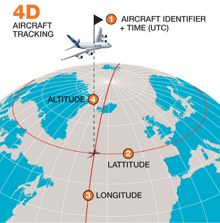
Section titled “Aircraft Tracking - 4D”An aircraft’s position is defined by transmission of its 4D (or four dimensions of Latitude, Longitude, Altitude, and Time data every 15 minutes, together with the aircraft’s identifier. Aircraft tracking refers to both normal tracking and abnormal tracking (Fig.2).
(fig.2)
Section titled “(fig.2)”Aircraft Tracking 4D or the four dimensions of Latitude, Longitude, Altitude, and Time data
Progress to Pinpoint an Aircraft’s Position
AIRCRAFT
Section titled “AIRCRAFT”Some examples of abnormal events may include unusual aircraft attitude, unusual speed or an engine failure in fl ight.
Tracking Aircraft During Normal & Abnormal Operations
Section titled “Tracking Aircraft During Normal & Abnormal Operations”Normal tracking is currently defi ned in ICAO and EC regulation projects. Abnormal tracking is not yet formally included in the regulation, but it is part of the guidance materials for aircraft tracking. Airbus endorses the implementation of abnormal tracking as it may become an industry requirement in the near future, or it can be implemented by the operator’s own initiative.
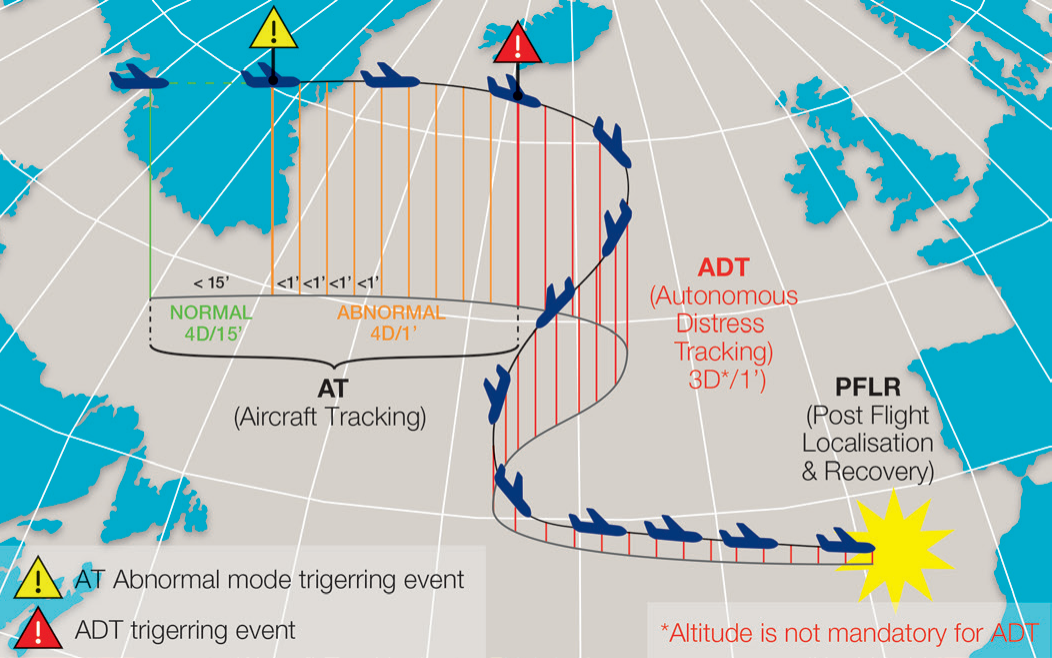
Tracking during “Normal Operations” requires an aircraft to transmit its 4D data at least once every 15 minutes. In a case where unexpected aircraft behaviour is detected, the “Abnormal Operations” mode automatically increases the position reporting frequency based on certain triggering parameters. If the conditions that led to the increased reporting rate cease to exist, the reporting would revert to the data transmission intervals of once every 15 minutes (Fig. 3).
Some examples of abnormal events may include unusal aircraft attitude, unusual speed or an engine failure in fl ight.
(fi g.3)
Section titled “(fi g.3)”Aircraft Tracking for Normal Operations and Abnormal Operations

NORMAL OPERATIONS ≤ 15 min.
ABNORMAL OPERATIONS 1 min.
Autonomous Distress Tracking
Section titled “Autonomous Distress Tracking”The objective of Autonomous Distress Tracking (ADT) is to provide the endof-fl ight aircraft position with greater accuracy that will enable the location of the accident site within a range of six nautical miles or a search and rescue region of less than roughly 100 square kilometres. The fi rst priority is to search for survivors and after the search and rescue phase is completed, the second priority is to recover fl ight data and cockpit voice recorders.
Deactivation of the ADT can only be possible using the same activating mechanism that initially activated the ADT transmission.
The ADT signal shall be triggered automatically by detecting in fl ight behaviours that are likely to lead to an accident if not corrected, or it can be triggered manually by the crew. Deactivation of the ADT can only be possible using the same activating mechanism that initially activated the ADT transmission. The system should be autonomous so the transmitting system has a back-up power supply, separated from the aircraft’s power in case there is an electrical system failure. This means using a battery with suitable life to sustain the transmission over a given time. It also requires means to autonomously transmit position information if this no longer available from the aircraft.
ICAO’s performance-based Standards And Recommended Practices (SARPs) for ADT are applicable from January 2021 for all newly manufactured aircraft. This requires that 3D position information (the altitude parameter is not mandatory for ADT to remain compatible with existing systems), is transmitted at least once every minute.
ADT Triggered Transmissions
Section titled “ADT Triggered Transmissions”Triggered Transmission is when predefined operational parameters of an aircraft in flight are monitored and data is transmitted automatically if the aircraft is in an uncertain situation, or when an aircraft in distress, meaning that it is in a situation, which if not corrected, will most probably result in an accident. The triggers are defined in the Eurocae Minimum Aviation System Performance Specifications (MASPS ED 237).
Examples of Aircraft Tracking Scenarios
Section titled “Examples of Aircraft Tracking Scenarios”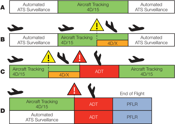
Source: ICAO GADSS ConOps
A. Nominal flight from an area under Air Traffic Services (ATS) surveillance to an areas outside of ATS coverage with normal mode 4D/15 Aircraft Tracking (AT) until ATS surveillance is reinstated.
B. A flight with an abnormal tracking condition (4D/X) triggered and transmitted outside of ATS surveillance area prior to reinstating ATS surveillance.
C. (i) A flight with an abnormal tracking condition (4D/X) triggered and transmitted outside of ATS surveillance area. (ii) A mechanism triggers the Automated Distress Tracking (ADT) transmission. (iii) ADT deactivated but ONLY by the SAME mechanism that activated the ADT.
D. (i) A flight with normal tracking or ATS surveillance. (ii) Aircraft situation triggers ADT transmission until the end of flight. (iii) Post Flight Location Recovery (PFLR)
4D/15 NORMAL TRACKING: Latitude/Longitude/Altitude/Time transmitted at least once every 15 minutes
4D/X ABNORMAL TRACKING: Latitude/Longitude/Altitude/Time transmitted at least once every minute
… ADT triggering logics were validated using a database of flight parameters collected from more than 50-thousand flights …
Progress to Pinpoint an Aircraft’s Position
AIRCRAFT
Section titled “AIRCRAFT”Avoiding any false alerts
Section titled “Avoiding any false alerts”When defining triggering logic, the challenge was to both ensure that all distress events are captured and avoid any “false positives” that could cause unnecessary reactions to a false alarm. In answer to this, Airbus conducted intensive analysis to validate that the parameters and the defined thresholds that would activate a triggered transmission were appropriate.
(fig.5)
Section titled “(fig.5)”Example of Normal and Abnormal Aircraft Tracking, Autonomous Distress Tracking and Post Flight Localisation & Recovery
For each of the Airbus aircraft families (A320, A330, A380, A350) the selected ADT triggering logics were validated using a database of flight parameters collected from more than 50-thousand flights of different aircraft types that were flown by several airlines and on a variety of routes.
AIRBUS SOLUTIONS FOR AIRCRAFT TRACKING
Section titled “AIRBUS SOLUTIONS FOR AIRCRAFT TRACKING”Airbus together with Rockwell Collins have developed an Aircraft Tracking Solution ready for Airlines to implement on the existing Airline Operational Control (AOC) function on Airbus aircraft with ACARS (Aircraft Communications Addressing and Reporting System) communication means. This requires no flight crew action, both for aircraft tracking in Normal mode (sending position at least every 15 minutes) and uses an Airbus optimized triggering logic for tracking Abnormal operations. This is implemented directly in the Rockwell Collins AOC dataframe on all A380 or A350 aircraft and A320 family, A330 and A340 aircraft furnished with Rockwell Collins ATSU (Fig. 6).
AOC hosted on ATSU AOC hosted on NSS/FSA-NG A320 / A340 / A330 A380 / A350 XWB Rockwell Collins Rockwell Collins Available Available contact contact Rocwell Collins for implementation Rocwell Collins for implementation Standard Database Airline Customized Airline Customized Customization Tool Database Database Standard Airline Customized Database Customization Database Tool AOC supplier implements a customized aircraft Tracking functions tracking function for the Airline The Airline are compatible with can implement a the latest standard customization aircraft database versions tracking function with the customization tool
A320 / A330 / A340 Aircraft Tracking
Section titled “A320 / A330 / A340 Aircraft Tracking”The AOC application is hosted on the Air Traffic Service Unit (ATSU) for these aircraft. For aircaft fitted with Rockwell Collins furnished ATSU, operators can implement tracking functions compatible with the latest standard database versions, or implement a customised aircraft tracking function specifically defined for the operator.
(fig.6)
Section titled “(fig.6)”Airbus Aircraft Tracking Solutions that can be implemented on the existing Airline Operational Control (AOC) function
A380 / A350 Aircraft Tracking
Section titled “A380 / A350 Aircraft Tracking”The AOC application is hosted on the Network Server System (NSS) for the A380 and the A350’s FSA-NG (FlySmart by Airbus - New Generation). Operators can implement a customised aircraft tracking function with the customisation tool with the implementation of this function by Rockwell Collins.
A300 / A310
Section titled “A300 / A310”Aircraft tracking for the A300 and A310 aircraft can be analysed by Airbus experts on request of the operator to determine a solution that is most suitable for each aircraft’s configuration.
Other Aircraft Tracking Solutions
Section titled “Other Aircraft Tracking Solutions”Space Based ADS-B
Section titled “Space Based ADS-B”All air transport aircraft will be equipped with ADS-B (Automatic Dependent Surveillance – Broadcast) transponders according to various mandates. Recently launched communications satellite constellations are capable of tracking ADS-B signals and global coverage is expected to be in place from 2018 when Aireon completes the placement of space ADS-B receivers on the Iridium NEXT constellation, consisting of 66 Low Earth Orbit (LEO) satellites. A spacebased ADS-B receiver network will relay signals from the aircraft to a service provider on the ground. This service will be capable of global real-time ADS-B
Progress to Pinpoint an Aircraft’s Position
AIRCRAFT
Section titled “AIRCRAFT”surveillance, even when flying over oceanic, polar and remote regions, and no modifications or changes should be necessary for aircraft already equipped with ADS-B transponders.
What about GPS navigation?
Section titled “What about GPS navigation?”GPS is prolific in our daily lives and modern smart phones give us its locating capabilities in our hands. It is true that most commercial aircraft today have ‘global navigation satellite system’ (GNSS) receivers on board to aid pilots with positioning and navigation. However, this information is telling the crew where their aircraft is but it does not send that information to the ground. GPS (or GNSS position) is however used by many systems on-board the aircraft, ADS-B being one of them.
How do flight tracking services show aircraft position for a flight, even over oceans?
Section titled “How do flight tracking services show aircraft position for a flight, even over oceans?”Flight tracking services, many available as apps on our smartphones, primarily use ADS-B data transmitted by aircraft to ground receivers. Some services also combine data from several data sources to increase the accuracy of their service including ADS-B, multi-lateration (or MLAT) and radar data. While this can often provide the first notification of an event or incident, there are limitations regarding the accuracy of the data as some of the displayed values may be aggregated or estimated depending on the service provider – especially for aircraft shown in the more remote areas with only ADS-B or no coverage. This kind of application alone may not be sufficient for meeting the aircraft tracking objectives of recently defined regulations and ICAO’s recommendations and operators should check with their respective National Aviation Authorities.
POST FLIGHT LOCALISATION AND RECOVERY
Section titled “POST FLIGHT LOCALISATION AND RECOVERY”The aim of tracking aircraft in distress is to more precisely establish the location of the aircraft’s end-of-flight, marking the accident site, within a 6 nautical miles radius (roughly 11 kilometres or 7 miles). ICAO requests implementation of means for localising an aircraft in distress from January 2021 for all new manufactured aircraft, and improvements to underwater locator beacons that will increase the chances of locating the wreckage underwater from January 2018.
The aim of tracking aircraft in distress is to more precisely establish the location of the aircraft’s end-offlight, marking the accident site, within a 6 nautical miles radius.
Aids to Locating an Accident Site
Section titled “Aids to Locating an Accident Site”It is the Autonomous Distress Tracking function that will help to determine the accident site and to launch the search and rescue operations. There is additional equipment installed on the aircraft itself that can aid in pinpointing the precise location of the wreckage and the flight data recorders.
Emergency Locator Transmitter (ELT)
Section titled “Emergency Locator Transmitter (ELT)”This article only refers to the automatic fixed ELT and not the portable or survival ELTs that can be found in the cabin.
The current fixed ELT is an autonomous beacon including a battery that is fixed to the top of the aircraft’s structure and triggered by impact sensors or the pilot from
the cockpit. Analysis of past accidents show that the ELT can often be destroyed in the crash or sink too far under water before the Cospas-Sarsat satellites* can pick-up the signal and determine the aircraft’s end-of-fl ight position.
*Cospas-Sarsat Programme is a satellite-based search and rescue (SAR) distress alert detection and information distribution system, best known for detecting and locating emergency beacons activated by aircraft, ships and backcountry hikers in distress
The regulations are evolving to propose improvements to the current ELT and may include pre-crash activation to transmit its position before impact. New generation ELT are currently under defi nition and development to be ready for implementation from 2021.
Underwater Locator Beacon (ULB)
Section titled “Underwater Locator Beacon (ULB)”ULBs are acoustic beacons that are activated when the aircraft is immersed in water. A ULB is attached to the each fl ight recorder.
ICAO annex 6 requests ULB with minimum of 90 days operation should be fi tted to replace the current standard of ULB with 30 days of battery-life at the earliest practical date, but no later than January 2018. Airbus is fi tting 90 day ULB to all newly manufactured aircraft and have launched a retrofi t campaign with Operators for the existing fl eet to install new standard ULB.
In addition, ICAO recommends that all operators install the low frequency ULB for all aircraft operating over water from January 2018 and EU regulation makes it mandatory for all aircraft operating over water from January 2019. This new low-frequency (LF) ULB transmits a signal at 8.8 kHz and will be fi tted to all new Airbus aircraft from this year. Retrofi t of the existing fl eet is also planned. When compared with the existing 37.5 kHz ULB, the detection range of the new LF-ULB is increased fourfold, up to 16nm or 29km based on a depth of 3 500m and depending on the surface conditions of the ocean.
(fi g.7)
Section titled “(fi g.7)”ICAO Annex Provisions with initial applicability in 2018-2021
2018 2019 2020 2021 2022 2023 Underwater Locating Devices ADT Function Annex 6 Part 1 Annex 6 Part 1 Applicable 01 Jan 2018 Applicable 01 Jan 2021 Aircraft Trancking Function Flight Recorder Data Recovery Annex 6 Part 1 Annex 6 Pert 1 Applicable 08 Nov 2018 Applicable 01 Jan 2021

Progress to Pinpoint an Aircraft’s Position
AIRCRAFT
Section titled “AIRCRAFT”Airbus will fit a deployable recorder device on its entire fleet of long range aircraft.
FINDING THE ‘BLACK BOXES’
Section titled “FINDING THE ‘BLACK BOXES’”There are cases, although rare, where the flight data and cockpit voice recorders, or “black boxes”, were submerged in the ocean and not recovered from the wreckage. In some other cases it took a long time to finally locate the recorders and then retrieve them from the ocean floor three to five kilometres below the surface. To avoid these scenarios in future, Airbus will fit a deployable recorder device on its entire fleet of long range aircraft with an aim to first install it on the A350XWB from 2019.
Regulation Drivers for Enhancing Flight Data and Cockpit Voice Recorders
Section titled “Regulation Drivers for Enhancing Flight Data and Cockpit Voice Recorders”Two types of recorders are currently required by the regulations on aircraft flying today. One is the Cockpit Voice Recorder (CVR), which must store the recordings of the cockpit voices and the text messages transmitted between the crew and controllers for the two hours prior to a serious incident or crash. The other is a Digital Flight Data Recorder (DFDR) that must retain the previous 25 hours of recorded flight parameters.
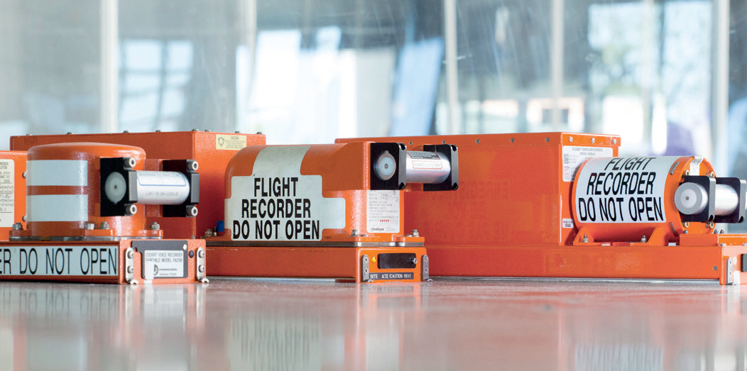
The CVR & DFDR are housed in separate units installed in the aircraft. Both are designed to resist impact forces of over 3,400G for 6.5 milliseconds and withstand temperatures of 1,100 degrees Celsius for 60 minutes. The recorders have an integrated Underwater Location Beacon (ULB) (Fig. 8).
(fig.8) Flight recorder devices installed on aircraft flying today
Recently adopted ICAO Annex 6 amendments propose new performance based requirements for large commercial aircraft applicable from January 2021. For all aircraft manufactured after this date, the CVR fitted must be able to store at least 25 hours of recordings to cover all phases of the flight and in all types of operations. Any aircraft delivered with new type certificate after January 2021 must also be equipped with the means for timely recovery of the flight data and cockpit voice recordings, avoiding the need for underwater retrieval.
A Combined Cockpit Voice and Flight Data Recorder
Section titled “A Combined Cockpit Voice and Flight Data Recorder”The ICAO requirement to increase voice recording time from 2 to 25 hours will be the new standard for recorders under development for all Airbus aircraft. These new recorders will combine the flight data and cockpit voice recording functions in a single device capable of storing 25 hours of voice, text communications and flight data.
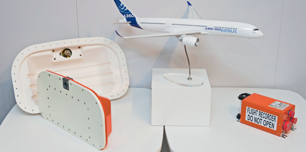
There will be two combined Cockpit Voice and Data Recorders (CVDR) devices fitted to new Airbus aircraft. One CVDR device will be fixed to the structure in the forward area of the aircraft (Fig.8a). A320 family aircraft will have a second CVDR fixed to the structure in its aft area. The second CVDR that will be fitted to the long-range aircraft families (A330, A350 XWB, A380 and including A321-LR) will be an Automatic Deployable Flight Recorder (ADFR) installed in the vertical tail plane area (Fig.9).
… new recorders will combine the flight data and cockpit voice recording functions in a single device capable of storing 25 hours of voice, text communications and flight data.
The Automatic Deployable Flight Recorder
Section titled “The Automatic Deployable Flight Recorder”Airbus is developing an Automatic Deployable Flight Recorder (ADFR) suitable for its entire fleet of long range aircraft where the aircraft will operate routes over remote areas or oceans for an extended period of time. ADFR will be available from 2019 on A350 XWB aircraft with the subsequent deployment for the remaining long range aircraft families.
It is not a new concept as deployable recorders have been used in both military aircraft and commercial helicopter operations for some time, but it is not precisely the same technology that is proposed for commercial aircraft. The principle is to install a lighter, more compact unit that combines the flight data recorder, cockpit voice recorder and an integrated Emergency Locator Transmitter (ELT), which will be deployed from the tail area of the aircraft using a spring loaded device moments before an accident. The device will be deployed if sensors detect airframe deformation or immersion in water. The crash protected recorder will be designed to survive the impact and float on the water, while transmitting its position and allowing the search and rescue services to more rapidly rescue any survivors and discover the wreckage.
(fig.9)
Section titled “(fig.9)”Showing design concepts for (a) combined Cockpit Voice and Data Recorder (CVDR) – right; and (b) the Automatic Deployable Flight Recorder (ADFR) – left.
Progress to Pinpoint an Aircraft’s Position
AIRCRAFT
Section titled “AIRCRAFT”Data Streaming
Section titled “Data Streaming”Increasingly, aircraft seem to be constantly connected in a way that enables passengers to make phone calls in the air, stream live television and use the internet via on-board Wi-Fi. Therefore, is it feasible to stream the aircraft’s Cockpit Voice Recorder and Flight Data Recorder via satellite?
Beyond the obvious ease of quickly recovering flight data, an advantage of a satellite streaming solution is the possibility of implementing a retrofit solution for aircraft flying today that are already equipped with the long range communication means. This can enable the timely recovery of flight data and cockpit voice recordings following a serious incident or accident, but the size and regularity of the data transmission over the available satellite bandwidth are to be defined. Although the cost of transmissions is constantly decreasing, agreements regarding usage and coverage of the available satellite constellations also need to be established.
Another issue to be addressed is the security of the transmitted data and also the privacy implications concerning streaming cockpit voice recordings. The questions of who owns the data, responsibility to store the data securely, what level of data encryption is required and who will manage the encryption keys for access in normal flight operations or restricted access for investigation of an accident are under discussion today within the ICAO led working groups, which are made up of representatives from all actors in the Air Transport System.
CONTRIBUTORS:
Section titled “CONTRIBUTORS:”Claude PICHAVANT Senior Expert Communications & Surveillance – Manage Flight Systems
Geraldine VALLEE Director of Flight Safety – Safety Enhancement
More accurate determination of the end-of-flight location reduces the search and rescue perimeter with the hope of finding survivors faster. Improvements to the Underwater Locator Beacon, and installation of the deployable recorders, will increase the chances of locating the submerged wreckage and enable a more timely recovery of flight recorders. This will make data more rapidly available to investigators.
Regulations are evolving based on the ICAO recommendations already in place for performance based requirements related to the tracking, localisation and eventual recovery of an aircraft in distress. Airbus is continuing to contribute to the various international working groups and support the standardisation of various aircraft solutions to comply with regulations. Aircraft tracking can be implemented today with fast and simple solutions available now for Airbus aircraft. Aircraft tracking function adds no additional workload for the flight crew.
The probability of a aircraft accident occurring is very low today, but if such an event was to occur, for an aircraft fitted with the tracking and localising enhancements described in this article, it is unlikely to be lost.
Safety fi rst
Section titled “Safety fi rst”Safety fi rst, #24 August, 2017. Safety fi rst is published by Airbus S.A.S. - 1, rond point Maurice Bellonte - 31707 Blagnac Cedex/France. Publisher and Editor: Yannick Malinge, Chief Product Safety Offi cer. Concept Design by Airbus Multi Media Support 20171210. Reference: X00D16031905 Issue 24. Photos by Airbus, Lindner Fotografi e, S. Ramadier, H. Goussé, P. Masclet, F. Lancelot, A, Doumenjou, J. V. Reymondon, A. Tchaikovsky, C. Sadonnet, P. Pigeyre, A. Balazh. Computer renderings by Fixion.
来源: Airbus Safety First 网址: https://safetyfirst.airbus.com/progress-to-pinpoint-an-aircrafts-position/ 发布日期: 2017-07-29 杂志期号: 2017-08 分类: Flight Ops, Maintenance, 4d, ADFR, ADS-B, beacon, black box, CVDR, CVR, data, deployable, DFDR, distress, ELT, locator, position, recorder, satcom, streaming, tracking, transmission, transmitter, ULB, underwater PDF: Original PDF
自法航447航班(AF447)在大西洋坠毁后花了两年时间才打捞到飞行数据记录器,以及2014年马航MH370航班失踪以来,整个航空运输系统中的各方参与者一直在共同努力改进飞机追踪和”黑匣子”回收技术。本文概述了各项建议和拟议法规,以及现有或正在开发的产品,这些将帮助空客飞机运营商遵守这些变更。本文还介绍了在发生事故时增强航班追踪和飞机定位的机会,以实现更快速的搜救行动,以及及时回收飞行数据。
自1958年以来对所有航空事故的分析表明,不到百分之十的致命事故发生在飞行的巡航阶段。在这个阶段,飞机在大约39,000英尺高度飞行于大洋或偏远地区上空,更可能处于雷达和地面追踪基础设施的覆盖范围之外。因此,只有少数事件会出现难以确定飞机最后位置、定位残骸并回收飞行数据记录器的情况。在过去20年中,有24架大型商用飞机需要进行水下打捞,其中只有一架尚未被定位。
飞机飞行追踪
Section titled “飞机飞行追踪”如今的商用飞机航班比以往任何时候都更加安全。在极少数发生事故的情况下,以最快的方式定位残骸是首要任务,首先是营救幸存者,然后回收飞行记录器或”黑匣子”。
能力与局限性
Section titled “能力与局限性”飞机追踪能力的提升可通过提供早期响应警报并更准确地定位飞行结束时的飞机位置来增加找到幸存者的机会,从而启动搜救(SAR)行动。这也有助于回收飞行数据记录器,帮助调查人员确定可能促成行业采取行动的参与因素,这些行动可能有助于防止事故再次发生。
过去的飞机追踪能力主要依赖于地面基础设施和有限的卫星覆盖。事实上,这意味着当飞机在大洋上空飞行,或在追踪基础设施未覆盖的地区(包括偏远地区和地球两极上空)飞行时,很难对其进行追踪。用于空中交通管制监视的一次雷达通常只能从大多数国家的海岸向外延伸大约200海里(约合不到400公里)。
如今,当飞机在大洋或偏远地区飞行且没有雷达或ADS-B覆盖时,飞行员使用无线电向空中交通管制报告飞机位置。或者可以通过ADS-C经由SATCOM或高频(HF)传输,这些是远程通信手段。VHF数据链已配备在空客全机队的所有飞机上。对于A320系列飞机,在需要飞越大洋或偏远地区的运行时,可以选择高频(HF)和卫星通信(SATCOM)选装设备**(图1)**。
……当飞机在大洋上空或追踪基础设施未覆盖的地区(包括偏远地区和地球两极上空)飞行时,很难对其进行追踪。
|---|---|---|---|
(图 1) 空客机队可用的数据链通信方式
追踪飞机的监管推动力
Section titled “追踪飞机的监管推动力”飞机追踪是指在飞行各阶段利用飞机位置信息。这有助于及时、准确地定位飞机事故现场,并回收飞行数据。国际民航组织(ICAO)发布了新的飞行追踪建议,适用于所有商业飞机。追踪飞机的责任由飞机运营人承担。
空客已制定可立即实施的解决方案,帮助运营人遵守最新的飞机追踪法规。各国家航空当局(NAA)可根据ICAO建议制定各自的法规。运营人应向其所属的NAA确认适用于自身的飞机追踪法规。
建议与法规的演进
Section titled “建议与法规的演进”自2014年以来,空客一直是ICAO和国际航空运输协会(IATA)成立的各工作组的重要贡献者,并继续作为关键行业利益相关方推动法规演进。
空客已制定可立即实施的解决方案,帮助运营人遵守最新的飞机追踪法规。
在2015年举行的高级安全会议上,ICAO鼓励各缔约国和国际电信联盟(ITU)紧急采纳法规,为全球空中交通服务提供必要的频谱分配,使飞机广播的地面ADS-B信号能够被卫星接收。这促使人们开始考虑ICAO全球航空遇险与安全系统(GADSS)引入和使用的频谱需求及监管规定。ICAO随后发布了概念运行(ConOps)文件,规定了GADSS的高级需求和目标。
飞机追踪的监管流程由ICAO GADSS ConOps文件发起,其建议随后被转化为ICAO基于性能的《标准和建议措施》(SARP)。正常飞行追踪的SARP于2018年11月起适用。各国家航空当局(NAA)将根据ICAO SARP制定和实施各自的法规。
飞机追踪——4D
Section titled “飞机追踪——4D”飞机位置通过传输其4D(即四个维度:纬度、经度、高度和时间数据)来定义,每15分钟传输一次,同时传输飞机标识符。飞机追踪包括正常追踪和异常追踪**(图 2)**。
飞机追踪4D:纬度、经度、高度和时间数据四个维度
定位飞机位置的进展
异常事件的示例可能包括飞机姿态异常、速度异常或飞行中发动机失效。
正常与异常运行期间的飞机追踪
Section titled “正常与异常运行期间的飞机追踪”正常追踪目前已在ICAO和欧共体法规草案中定义。异常追踪尚未正式纳入法规,但它是飞机追踪指导材料的一部分。空客支持实施异常追踪,因为这可能在不久的将来成为行业要求,或者可由运营人自行决定实施。
“正常运行”期间的追踪要求飞机至少每15分钟传输一次其4D数据。在检测到飞机意外行为的情况下,“异常运行”模式会根据某些触发参数自动增加位置报告频率。如果导致报告频率增加的条件不再存在,则报告将恢复到每15分钟一次的数据传输间隔**(图 3)**。
异常事件的示例可能包括飞机姿态异常、速度异常或飞行中发动机失效。
正常运行和异常运行的飞机追踪
正常运行 ≤ 15 分钟
异常运行 1 分钟
自主遇险追踪
Section titled “自主遇险追踪”自主遇险追踪(ADT)的目标是提供更精确的飞行结束时飞机位置,使事故现场定位范围在6海里以内,或搜救区域小于约100平方公里。第一优先任务是搜寻幸存者,搜救阶段完成后,第二优先任务是回收飞行数据和驾驶舱语音记录器。
ADT的关闭只能使用当初激活ADT传输的相同激活机制。
ADT信号应通过自动检测可能导致事故(如未纠正)的飞行行为来触发,也可由机组人工触发。ADT的关闭只能使用当初激活ADT传输的相同激活机制。该系统应具备自主性,以便发射系统具有独立于飞机电源的备用电源,以防电气系统发生故障。这意味着需要使用具有足够寿命的电池以在给定时间内维持传输。同时还需要能够在飞机不再提供位置信息时自主传输位置信息的手段。
ICAO基于性能的ADT《标准和建议措施》(SARP)自2021年1月起适用于所有新制造的飞机。这要求至少每分钟传输一次3D位置信息(高度参数对于ADT不是强制性的,以保持与现有系统的兼容性)。
触发传输(ADT)
Section titled “触发传输(ADT)”触发传输是指对飞行中飞机的预定义运行参数进行监控,并在飞机处于不确定状况时或在飞机处于遇险状态(即如果不加以纠正很可能导致事故的状况)时自动传输数据。触发条件在欧航空电子设备制造商协会(Eurocae)最低航空系统性能规范(MASPS ED 237)中定义。
飞机追踪场景示例
Section titled “飞机追踪场景示例”
来源:ICAO GADSS ConOps
A. 从空中交通服务(ATS)监视区域内的正常航班飞行到ATS覆盖范围外的区域,期间以正常模式进行4D/15飞机追踪(AT),直到恢复ATS监视。
B. 在恢复ATS监视之前,在ATS监视范围外触发并传输异常追踪状态(4D/X)的航班。
C. (i) 在ATS监视范围外触发并传输异常追踪状态(4D/X)的航班。(ii) 一种机制触发自动遇险追踪(ADT)传输。(iii) ADT仅能由激活ADT的同一机制停用。
D. (i) 正常追踪或ATS监视的航班。(ii) 飞机状况触发ADT传输直至飞行结束。(iii) 飞行后位置恢复(PFLR)
4D/15正常追踪:至少每15分钟传输一次经度/纬度/高度/时间
4D/X异常追踪:至少每分钟传输一次经度/纬度/高度/时间
… 使用从超过5万次飞行中收集的飞行参数数据库对ADT触发逻辑进行了验证…
确定飞机位置的研究进展
在定义触发逻辑时,挑战在于既要确保捕捉所有遇险事件,又要避免任何可能导致对误报做出不必要反应的“误报”。为此,空客进行了深入分析,以验证激活触发传输的参数和定义的阈值是否适当。
正常与异常飞机追踪、自主遇险追踪及飞行后定位与恢复示例
对于空客各机型系列(A320、A330、A380、A350),使用从不同机型(由多家航空公司执飞、不同航线)的5万余次飞行中收集的飞行参数数据库,对所选的ADT触发逻辑进行了验证。
空客飞机追踪解决方案
Section titled “空客飞机追踪解决方案”空客与Rockwell Collins共同开发了飞机追踪解决方案,可供航空公司在空客飞机的现有航空运营控制(AOC)功能上实施。该方案使用ACARS(飞机通信寻址与报告系统)通信方式,无需飞行员操作即可实现正常模式下的飞机追踪(至少每15分钟发送一次位置),并采用空客优化的触发逻辑进行异常追踪。此功能已直接在Rockwell Collins AOC数据帧中实现,适用于所有A380或A350飞机以及配备Rockwell Collins ATSU的A320系列、A330和A340飞机**(图6)**。
AOC托管于ATSU AOC托管于NSS/FSA-NG A320/A340/A330 A380/A350 XWB Rockwell Collins Rockwell Collins 可用 可用 请联系 请联系 Rockwell Collins Rockwell Collins实施 实施 标准数据库 航空公司定制 航空公司定制 定制工具 数据库 数据库 标准 航空公司定制数据库 定制工具 AOC供应商实施定制飞机追踪功能 航空公司可实施兼容最新标准数据库版本的定制追踪功能
A320/A330/A340飞机追踪
Section titled “A320/A330/A340飞机追踪”AOC应用托管于这些飞机的空中交通服务单元(ATSU)。对于配备Rockwell Collins提供的ATSU的飞机,运营商可以实施与最新标准数据库版本兼容的追踪功能,或实施专门为运营商定义的定制飞机追踪功能。
可在现有航空运营控制(AOC)功能上实施的空客飞机追踪解决方案
A380/A350飞机追踪
Section titled “A380/A350飞机追踪”AOC应用托管于A380的网络服务器系统(NSS)和A350的FSA-NG(空客飞行智能——新一代)。运营商可以使用定制工具实施定制飞机追踪功能,由Rockwell Collins负责实施。
A300/A310
Section titled “A300/A310”空客专家可根据运营商要求对A300和A310飞机的飞机追踪进行分析,以确定最适合各飞机配置的解决方案。
其他飞机追踪解决方案
Section titled “其他飞机追踪解决方案”星基ADS-B
Section titled “星基ADS-B”根据各种强制要求,所有运输飞机将配备ADS-B(广播式自动相关监视)应答机。最近发射的通信卫星星座能够追踪ADS-B信号,当Aireon在由66颗低地球轨道(LEO)卫星组成的铱星NEXT星座上完成星基ADS-B接收器的部署后,预计2018年可实现全球覆盖。星基ADS-B接收器网络将把飞机信号中继到地面服务提供商。该服务能够实现全球实时ADS-B
确定飞机位置的研究进展
监视,即使在飞越大洋、北极和偏远地区时也是如此,已装备 ADS-B 应答机的航空器无需进行任何改装或变更。
GPS 导航呢?
Section titled “GPS 导航呢?”GPS 在我们的日常生活中无处不在,现代智能手机让我们能够随时使用其定位功能。诚然,大多数现代商用航空器都搭载了“全球导航卫星系统”(GNSS)接收机,以辅助飞行员进行定位和导航。然而,这些信息只能告诉机组人员他们的航空器在哪里,并不会将该信息发送到地面。GPS(或 GNSS 位置)却被航空器上的许多系统所使用,ADS-B 就是其中之一。
航班追踪服务如何显示航空器在大洋上空飞行的位置?
Section titled “航班追踪服务如何显示航空器在大洋上空飞行的位置?”航班追踪服务(其中许多以智能手机应用程序的形式提供)主要使用航空器向地面接收器传输的 ADS-B 数据。部分服务还结合了多种数据源来提高其服务精度,包括 ADS-B、多点定位(MLAT)和雷达数据。虽然这通常可以提供事件或事故的首要通知,但数据的准确性存在一定局限性,某些显示值可能因服务提供商的不同而被汇总或估算——尤其是在仅依赖 ADS-B 或无覆盖的偏远地区显示的航空器。此类应用程序本身可能不足以满足近期法规和 ICAO 建议中关于航空器追踪的目标,运营人应咨询其相应的国家航空当局。
飞行后定位与搜寻
Section titled “飞行后定位与搜寻”对遇险航空器进行追踪的目的是更精确地确定航空器飞行终止点的位置,将事故现场定位在 6 海里半径范围内(约 11 公里或 7 英里)。ICAO 要求从 2021 年 1 月起为所有新制造的航空器实施遇险定位手段,并从 2018 年 1 月起改进水下定位信标,以增加在水下定位飞机残骸的机会。
对遇险航空器进行追踪的目的是更精确地确定航空器飞行终止点的位置,将事故现场定位在 6 海里半径范围内。
事故现场定位辅助设备
Section titled “事故现场定位辅助设备”自主遇险追踪功能将有助于确定事故现场并启动搜救行动。航空器上还安装了额外的设备,可以帮助精确定位残骸和飞行数据记录器的位置。
应急定位发射机(ELT)
Section titled “应急定位发射机(ELT)”本文仅涉及自动固定式 ELT,不涉及可在客舱中发现的便携式或救生式 ELT。
当前的固定式 ELT 是一种自主信标,包含固定在航空器结构顶部的电池,由撞击传感器或飞行员从驾驶舱触发。过往事故分析表明,ELT 通常会在撞击中被摧毁,或在下沉至水面以下过深处后,Cospas-Sarsat 卫星*才能捕获信号并确定航空器的飞行终止位置。
*Cospas-Sarsat 计划是一个基于卫星的搜索与救援(SAR)遇险警报检测与信息分发系统,以其对航空器、船舶和野外徒步旅行者激活的紧急信标的探测和定位而最为著称
法规正在不断演进,以改进当前的 ELT,可能包括在撞击前激活以传输其位置。新一代 ELT 目前正在定义和开发中,计划于 2021 年起实施。
水下定位信标(ULB)
Section titled “水下定位信标(ULB)”ULB 是当航空器浸入水中时激活的声学信标。ULB 固定在每个飞行记录器上。
ICAO 附件 6 要求在切实可行的最早日期(但不迟于 2018 年 1 月)用至少 90 天运行时间的 ULB 替换现行 30 天电池寿命标准的 ULB。空客正在为所有新制造的航空器配备 90 天 ULB,并已启动针对现役机队的改装计划,以安装新标准 ULB。
此外,ICAO 建议所有运营人从 2018 年 1 月起为所有在水上运行的航空器安装低频 ULB,而欧盟法规则要求从 2019 年 1 月起对所有在水上运行的航空器强制安装。这种新的低频(LF)ULB 以 8.8 kHz 的频率传输信号,将从今年起配备在所有新造的空中客车航空器上。现役机队的改装也已在计划中。与现有的 37.5 kHz ULB 相比,新型 LF-ULB 的探测范围增加了四倍,在 3500 米深度下可达 16 海里或 29 公里,具体取决于海洋表面条件。
ICAO 附件条款——2018-2021 年初步适用
2018 2019 2020 2021 2022 2023 水下定位设备 自主遇险追踪功能 附件 6 第 1 部分 附件 6 第 1 部分 适用日期:2018 年 1 月 1 日 适用日期:2021 年 1 月 1 日 航空器追踪功能 飞行记录器数据恢复 附件 6 第 1 部分 附件 6 第 1 部分 适用日期:2018 年 11 月 8 日 适用日期:2021 年 1 月 1 日
精确定位航空器位置的进展
空客将在其所有远程飞机上安装可弹射式记录器设备。
寻找”黑匣子”
Section titled “寻找”黑匣子””虽然罕见,但曾发生过飞行数据记录器和驾驶舱语音记录器(即”黑匣子”)沉入海底且未能从残骸中打捞上来的情况。在其他一些案例中,定位记录器耗费了很长时间,随后又需要从海面下三至五公里处的海底将其打捞上来。为避免未来再次发生此类情况,空客将在其所有远程飞机上安装可弹射式记录器设备,并计划从2019年起率先在A350 XWB上安装。
增强飞行数据记录器和驾驶舱语音记录器的法规推动因素
Section titled “增强飞行数据记录器和驾驶舱语音记录器的法规推动因素”目前航空法规要求飞机安装两种类型的记录器。一种是驾驶舱语音记录器(CVR),必须储存严重事故或坠机前两小时内的驾驶舱语音和机组与管制员之间传输的文本信息。另一种是数字飞行数据记录器(DFDR),必须保留过去25小时的已记录飞行参数。
CVR和DFDR安装在飞机上独立的单元中。两者均设计为可抵抗超过3,400G持续6.5毫秒的撞击力,并能承受1,100摄氏度达60分钟的高温。记录器集成有水下定位信标(ULB)(图8)。
(图8) 当前在役飞机上的飞行记录器设备
近期通过的ICAO附件6修订案提出了适用于大型商业飞机的新性能要求,自2021年1月起生效。对于该日期之后制造的所有飞机,所安装的CVR必须能够储存至少25小时的录音,以覆盖所有飞行阶段和所有类型的运行。任何在2021年1月之后交付且带有新型号合格证的飞机也必须配备及时恢复飞行数据和驾驶舱语音记录的手段,无需进行水下打捞。
驾驶舱语音与飞行数据组合记录器
Section titled “驾驶舱语音与飞行数据组合记录器”ICAO将语音记录时间从2小时增加到25小时的要求将成为空客所有在研飞机记录器的新标准。这些新型记录器将把飞行数据记录和驾驶舱语音记录功能整合到单一设备中,可储存25小时的语音、文本通信和飞行数据。
新型空客飞机将安装两台组合式驾驶舱语音与数据记录器(CVDR)。一台CVDR固定安装在飞机前部区域(图8a)。A320系列飞机将第二台CVDR固定安装在飞机后部区域。远程飞机系列(A330、A350 XWB、A380及包括A321-LR在内)将安装的第二台CVDR为自动弹射式飞行记录器(ADFR),安装在垂直尾翼区域**(图9)**。
…新型记录器将把飞行数据记录和驾驶舱语音记录功能整合到单一设备中,可储存25小时的语音、文本通信和飞行数据。
自动弹射式飞行记录器
Section titled “自动弹射式飞行记录器”空客正在为其所有远程飞机开发自动弹射式飞行记录器(ADFR),这些飞机在偏远地区或大洋上空执飞航线的时间较长。ADFR将于2019年起在A350 XWB飞机上使用,随后将部署到其余远程飞机系列。
这并非新概念,因为可弹射式记录器已在军用飞机和商用直升机运营中使用了一段时间,但其技术与拟议用于商业飞机的不完全相同。原理是安装一个更轻、更紧凑的单元,整合飞行数据记录器、驾驶舱语音记录器和集成应急定位发射机(ELT),该设备将在事故发生前通过弹簧装置从飞机尾部弹射而出。当传感器检测到机体变形或浸入水中时,设备将被弹射。 crash protected recorder will be designed to survive the impact and float on the water, while transmitting its position and allowing the search and rescue services to more rapidly rescue any survivors and discover the wreckage.
(fig.9)
Section titled “(fig.9)”展示设计概念:(a) 组合式驾驶舱语音与数据记录器 (CVDR) – 右侧;(b) 自动弹射式飞行记录器 (ADFR) – 左侧。
精准定位飞机位置的技术进展
数据实时传输
Section titled “数据实时传输”如今飞机似乎始终保持连接状态,乘客可以在空中拨打电话、观看直播电视,并通过机载Wi-Fi使用互联网。那么,通过卫星实时传输驾驶舱语音记录器和飞行数据记录器是否可行?
卫星实时传输解决方案除了能快速恢复飞行数据这一明显优势外,还具有为已配备远程通信手段的现役飞机实施改装的可行性。这可以确保在发生严重事故或事故后及时恢复飞行数据和驾驶舱语音记录,但需确定通过可用卫星带宽传输的数据量和传输频率。虽然传输成本不断下降,但关于使用和覆盖可用卫星星座的协议也需要建立。
另一个需要解决的问题是传输数据的安全性,以及实时传输驾驶舱语音录音的隐私问题。谁拥有这些数据、负责安全存储数据的责任、需要何种级别的数据加密、在正常飞行运营或事故调查中谁将管理访问加密密钥——这些问题目前正在ICAO领导的工作组内讨论,工作组成员来自航空运输系统的各方代表。
Claude PICHAVANT 通信与监视高级专家 – 飞行系统管理
Geraldine VALLEE 飞行安全总监 – 安全提升
更准确地确定飞行结束位置可以缩小搜救范围,有望更快找到幸存者。对水下定位信标(ULB)的改进以及可弹射式记录器的安装,将提高定位沉没残骸的机会,并实现更及时地回收飞行记录器。这将使调查人员能够更快获取数据。
法规正根据ICAO已发布的关于飞机遇险追踪、定位和最终回收性能要求的相关建议不断演进空中客车公司将继续为各国际工作组做出贡献,并支持各种飞机解决方案的标准化以符合法规要求。飞机追踪功能目前可通过快速、简单的解决方案在空客飞机上实现。飞机追踪功能不会增加飞行机组的工作负荷。
飞机事故发生的概率目前非常低,但万一发生此类事件,对于配备本文所述追踪和定位增强功能的飞机来说,不太可能会失踪。
Safety fi rst
Section titled “Safety fi rst”Safety fi rst, #24 2017年8月。Safety fi rst由空中客车公司出版发行 – 1, rond point Maurice Bellonte - 31707 Blagnac Cedex/法国。出版人和编辑:Yannick Malinge,首席产品安全官。概念设计:空中客车多媒体支持 20171210。编号:X00D16031905 第24期。照片来源:空中客车公司、Lindner Fotografi e、S. Ramadier、H. Goussé、P. Masclet、F. Lancelot、A. Doumenjou、J. V. Reymondon、A. Tchaikovsky、C. Sadonnet、P. Pigeyre、A. Balazh。计算机渲染:Fixion。